You are here: Home > Network List > II - Global Seismograph Network (GSN - IRIS/IDA) Stations List
> Station WRAB Tennant Creek, NT, Australia > Earthquake Result Viewer
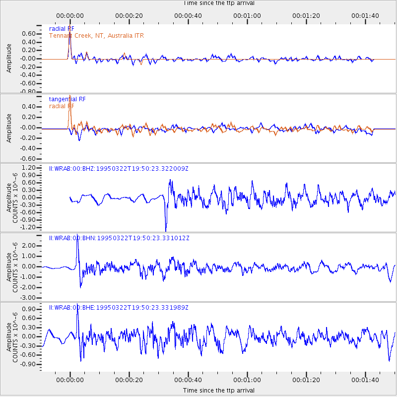
WRAB Tennant Creek, NT, Australia - Earthquake Result Viewer
*The percent match for this event was below the threshold and hence no stack was calculated.
| Earthquake location: |
Cook Strait, New Zealand |
| Earthquake latitude/longitude: |
-41.0/174.1 |
| Earthquake time(UTC): |
1995/03/22 (081) 19:43:30 GMT |
| Earthquake Depth: |
90 km |
| Earthquake Magnitude: |
5.5 MB |
| Earthquake Catalog/Contributor: |
WHDF/NEIC |
|
| Network: |
II Global Seismograph Network (GSN - IRIS/IDA) |
| Station: |
WRAB Tennant Creek, NT, Australia |
| Lat/Lon: |
19.93 S/134.36 E |
| Elevation: |
366 m |
|
| Distance: |
39.7 deg |
| Az: |
289.853 deg |
| Baz: |
130.854 deg |
| Ray Param: |
$rayparam |
*The percent match for this event was below the threshold and hence was not used in the summary stack. |
|
| Radial Match: |
75.952415 % |
| Radial Bump: |
383 |
| Transverse Match: |
58.47798 % |
| Transverse Bump: |
400 |
| SOD ConfigId: |
4480 |
| Insert Time: |
2010-03-01 23:31:38.496 +0000 |
| GWidth: |
2.5 |
| Max Bumps: |
400 |
| Tol: |
0.001 |
|
Signal To Noise
| Channel | StoN | STA | LTA |
| II:WRAB:00:BHN:19950322T19:50:23.331012Z | 15.131712 | 1.0893871E-6 | 7.199364E-8 |
| II:WRAB:00:BHE:19950322T19:50:23.331989Z | 2.9836698 | 3.7018438E-7 | 1.2407016E-7 |
| II:WRAB:00:BHZ:19950322T19:50:23.322009Z | 4.1744523 | 4.701845E-7 | 1.1263382E-7 |
| Arrivals |
| Ps | |
| PpPs | |
| PsPs/PpSs | |


