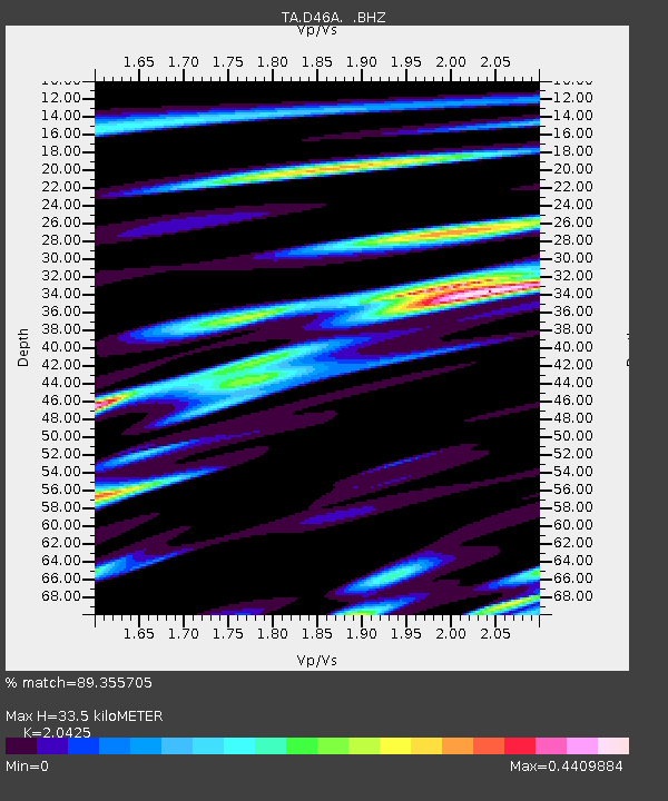
D46A Sault St. Marie, ON, CAN - Earthquake Result Viewer

Earthquake location: Rat Islands, Aleutian Islands
Earthquake latitude/longitude: 52.3/176.7
Earthquake time(UTC): 2014/06/24 (175) 03:15:36 GMT
Earthquake Depth: 4.0 km
Earthquake Magnitude: 6.3 MWB, 5.7 ML, 6.4 MWC, 6.6 MI
Earthquake Catalog/Contributor: NEIC PDE/NEIC COMCAT
Network: TA USArray Transportable Network (new EarthScope stations)
Station: D46A Sault St. Marie, ON, CAN
Lat/Lon: 46.89 N/84.04 W
Elevation: 353 m
Distance: 59.6 deg
Az: 51.714 deg
Baz: 315.285 deg
Ray Param: 0.06210393
Estimated Moho Depth: 33.5 km
Estimated Crust Vp/Vs: 2.04
Assumed Crust Vp: 6.467 km/s
Estimated Crust Vs: 3.166 km/s
Estimated Crust Poisson's Ratio: 0.34
Radial Match: 89.355705 %
Radial Bump: 400
Transverse Match: 80.47065 %
Transverse Bump: 400
SOD ConfigId: 739768
Insert Time: 2014-07-08 04:09:08.776 +0000
GWidth: 2.5
Max Bumps: 400
Tol: 0.001

Signal To Noise

ChannelStoNSTALTA
TA:D46A: :BHZ:20140624T03:25:10.249993Z6.3832688.5199616E-71.3347335E-7
TA:D46A: :BHN:20140624T03:25:10.249993Z2.4950633.0814917E-71.2350357E-7
TA:D46A: :BHE:20140624T03:25:10.249993Z1.93526162.8792908E-71.4878046E-7
Arrivals
Ps5.6 SECOND
PpPs15 SECOND
PsPs/PpSs21 SECOND