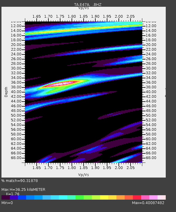
E47A Iron Bridge, ON, CAN - Earthquake Result Viewer

Earthquake location: Rat Islands, Aleutian Islands
Earthquake latitude/longitude: 52.3/176.7
Earthquake time(UTC): 2014/06/24 (175) 03:15:36 GMT
Earthquake Depth: 4.0 km
Earthquake Magnitude: 6.3 MWB, 5.7 ML, 6.4 MWC, 6.6 MI
Earthquake Catalog/Contributor: NEIC PDE/NEIC COMCAT
Network: TA USArray Transportable Network (new EarthScope stations)
Station: E47A Iron Bridge, ON, CAN
Lat/Lon: 46.45 N/83.28 W
Elevation: 246 m
Distance: 60.3 deg
Az: 51.637 deg
Baz: 315.796 deg
Ray Param: 0.061661433
Estimated Moho Depth: 36.25 km
Estimated Crust Vp/Vs: 1.76
Assumed Crust Vp: 6.467 km/s
Estimated Crust Vs: 3.674 km/s
Estimated Crust Poisson's Ratio: 0.26
Radial Match: 90.31878 %
Radial Bump: 293
Transverse Match: 85.49653 %
Transverse Bump: 400
SOD ConfigId: 739768
Insert Time: 2014-07-08 04:10:08.224 +0000
GWidth: 2.5
Max Bumps: 400
Tol: 0.001

Signal To Noise

ChannelStoNSTALTA
TA:E47A: :BHZ:20140624T03:25:14.874993Z6.395279.449164E-71.4775239E-7
TA:E47A: :BHN:20140624T03:25:14.874993Z3.77141173.8705303E-71.0262816E-7
TA:E47A: :BHE:20140624T03:25:14.874993Z1.86013442.5184244E-71.3538939E-7
Arrivals
Ps4.5 SECOND
PpPs15 SECOND
PsPs/PpSs19 SECOND