You are here: Home > Network List > II - Global Seismograph Network (GSN - IRIS/IDA) Stations List
> Station WRAB Tennant Creek, NT, Australia > Earthquake Result Viewer
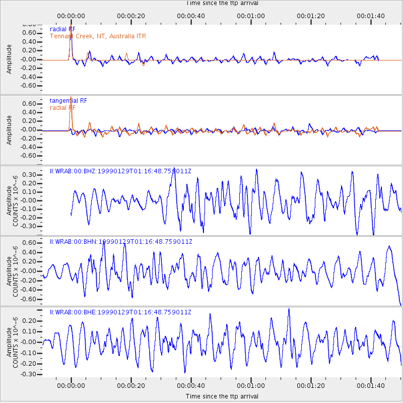
WRAB Tennant Creek, NT, Australia - Earthquake Result Viewer
*The percent match for this event was below the threshold and hence no stack was calculated.
| Earthquake location: |
Fiji Islands Region |
| Earthquake latitude/longitude: |
-15.9/-179.7 |
| Earthquake time(UTC): |
1999/01/29 (029) 01:09:16 GMT |
| Earthquake Depth: |
33 km |
| Earthquake Magnitude: |
5.7 MS, 5.3 MB, 5.9 MW, 5.9 MW |
| Earthquake Catalog/Contributor: |
WHDF/NEIC |
|
| Network: |
II Global Seismograph Network (GSN - IRIS/IDA) |
| Station: |
WRAB Tennant Creek, NT, Australia |
| Lat/Lon: |
19.93 S/134.36 E |
| Elevation: |
366 m |
|
| Distance: |
43.8 deg |
| Az: |
257.615 deg |
| Baz: |
92.36 deg |
| Ray Param: |
$rayparam |
*The percent match for this event was below the threshold and hence was not used in the summary stack. |
|
| Radial Match: |
78.087494 % |
| Radial Bump: |
341 |
| Transverse Match: |
38.2388 % |
| Transverse Bump: |
400 |
| SOD ConfigId: |
4480 |
| Insert Time: |
2010-03-01 23:31:41.941 +0000 |
| GWidth: |
2.5 |
| Max Bumps: |
400 |
| Tol: |
0.001 |
|
Signal To Noise
| Channel | StoN | STA | LTA |
| II:WRAB:00:BHN:19990129T01:16:48.759011Z | 2.208841 | 2.053679E-7 | 9.2975405E-8 |
| II:WRAB:00:BHE:19990129T01:16:48.759011Z | 1.2328173 | 1.4377395E-7 | 1.1662227E-7 |
| II:WRAB:00:BHZ:19990129T01:16:48.759011Z | 2.4430826 | 2.0552352E-7 | 8.412467E-8 |
| Arrivals |
| Ps | |
| PpPs | |
| PsPs/PpSs | |


