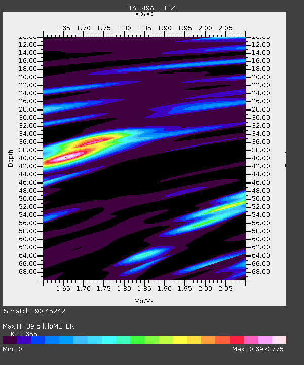
F49A Sandfield, ON, CAN - Earthquake Result Viewer
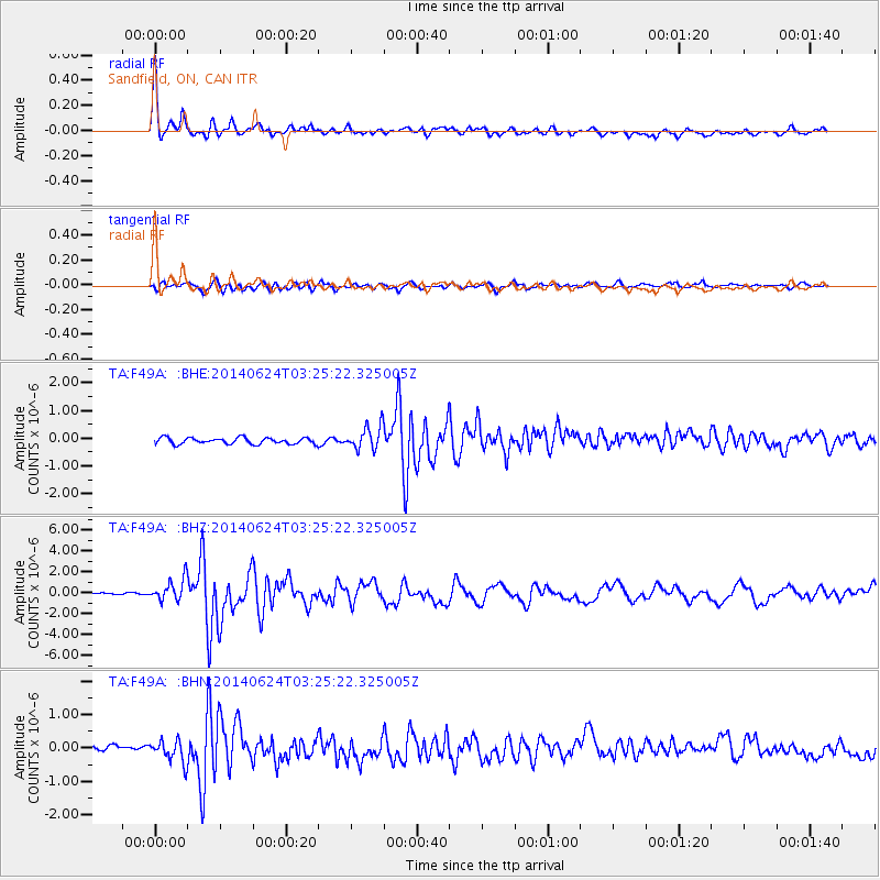
Earthquake location: Rat Islands, Aleutian Islands
Earthquake latitude/longitude: 52.3/176.7
Earthquake time(UTC): 2014/06/24 (175) 03:15:36 GMT
Earthquake Depth: 4.0 km
Earthquake Magnitude: 6.3 MWB, 5.7 ML, 6.4 MWC, 6.6 MI
Earthquake Catalog/Contributor: NEIC PDE/NEIC COMCAT
Network: TA USArray Transportable Network (new EarthScope stations)
Station: F49A Sandfield, ON, CAN
Lat/Lon: 45.76 N/82.04 W
Elevation: 230 m
Distance: 61.4 deg
Az: 51.475 deg
Baz: 316.605 deg
Ray Param: 0.06093757
Estimated Moho Depth: 39.5 km
Estimated Crust Vp/Vs: 1.65
Assumed Crust Vp: 6.483 km/s
Estimated Crust Vs: 3.917 km/s
Estimated Crust Poisson's Ratio: 0.21
Radial Match: 90.45242 %
Radial Bump: 340
Transverse Match: 80.211205 %
Transverse Bump: 400
SOD ConfigId: 739768
Insert Time: 2014-07-08 04:11:13.647 +0000
GWidth: 2.5
Max Bumps: 400
Tol: 0.001

Signal To Noise

ChannelStoNSTALTA
TA:F49A: :BHZ:20140624T03:25:22.325005Z6.09841061.093142E-61.792503E-7
TA:F49A: :BHN:20140624T03:25:22.325005Z4.6624053.3173515E-77.115108E-8
TA:F49A: :BHE:20140624T03:25:22.325005Z3.76611454.206837E-71.1170232E-7
Arrivals
Ps4.2 SECOND
PpPs15 SECOND
PsPs/PpSs20 SECOND