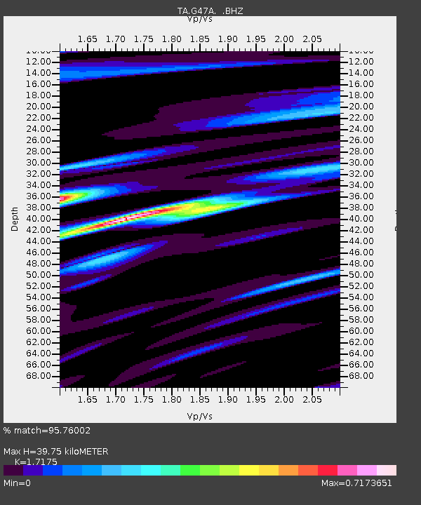
G47A Hillman, MI, USA - Earthquake Result Viewer
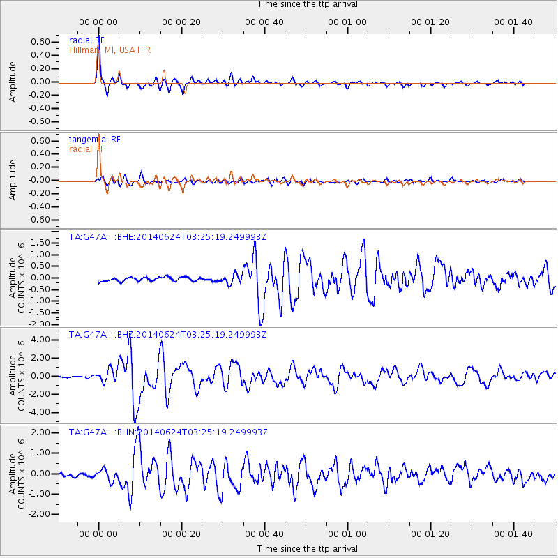
Earthquake location: Rat Islands, Aleutian Islands
Earthquake latitude/longitude: 52.3/176.7
Earthquake time(UTC): 2014/06/24 (175) 03:15:36 GMT
Earthquake Depth: 4.0 km
Earthquake Magnitude: 6.3 MWB, 5.7 ML, 6.4 MWC, 6.6 MI
Earthquake Catalog/Contributor: NEIC PDE/NEIC COMCAT
Network: TA USArray Transportable Network (new EarthScope stations)
Station: G47A Hillman, MI, USA
Lat/Lon: 45.17 N/83.86 W
Elevation: 239 m
Distance: 60.9 deg
Az: 52.993 deg
Baz: 316.05 deg
Ray Param: 0.061238106
Estimated Moho Depth: 39.75 km
Estimated Crust Vp/Vs: 1.72
Assumed Crust Vp: 6.483 km/s
Estimated Crust Vs: 3.774 km/s
Estimated Crust Poisson's Ratio: 0.24
Radial Match: 95.76002 %
Radial Bump: 389
Transverse Match: 79.98729 %
Transverse Bump: 400
SOD ConfigId: 739768
Insert Time: 2014-07-08 04:11:55.488 +0000
GWidth: 2.5
Max Bumps: 400
Tol: 0.001

Signal To Noise

ChannelStoNSTALTA
TA:G47A: :BHZ:20140624T03:25:19.249993Z7.43125257.483122E-71.0069799E-7
TA:G47A: :BHN:20140624T03:25:19.249993Z2.17077332.6989198E-71.2432987E-7
TA:G47A: :BHE:20140624T03:25:19.249993Z2.34277941.9551364E-78.345371E-8
Arrivals
Ps4.6 SECOND
PpPs16 SECOND
PsPs/PpSs20 SECOND