You are here: Home > Network List > II - Global Seismograph Network (GSN - IRIS/IDA) Stations List
> Station WRAB Tennant Creek, NT, Australia > Earthquake Result Viewer
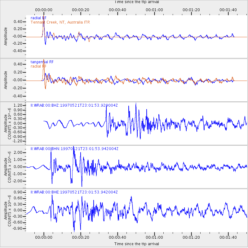
WRAB Tennant Creek, NT, Australia - Earthquake Result Viewer
*The percent match for this event was below the threshold and hence no stack was calculated.
| Earthquake location: |
Southern India |
| Earthquake latitude/longitude: |
23.1/80.0 |
| Earthquake time(UTC): |
1997/05/21 (141) 22:51:28 GMT |
| Earthquake Depth: |
36 km |
| Earthquake Magnitude: |
6.0 MB, 5.6 MS, 5.8 UNKNOWN, 5.6 ME |
| Earthquake Catalog/Contributor: |
WHDF/NEIC |
|
| Network: |
II Global Seismograph Network (GSN - IRIS/IDA) |
| Station: |
WRAB Tennant Creek, NT, Australia |
| Lat/Lon: |
19.93 S/134.36 E |
| Elevation: |
366 m |
|
| Distance: |
68.1 deg |
| Az: |
124.541 deg |
| Baz: |
306.267 deg |
| Ray Param: |
$rayparam |
*The percent match for this event was below the threshold and hence was not used in the summary stack. |
|
| Radial Match: |
79.13729 % |
| Radial Bump: |
400 |
| Transverse Match: |
57.24416 % |
| Transverse Bump: |
400 |
| SOD ConfigId: |
4480 |
| Insert Time: |
2010-03-01 23:31:43.834 +0000 |
| GWidth: |
2.5 |
| Max Bumps: |
400 |
| Tol: |
0.001 |
|
Signal To Noise
| Channel | StoN | STA | LTA |
| II:WRAB:00:BHN:19970521T23:01:53.942004Z | 3.6493104 | 8.170213E-7 | 2.2388376E-7 |
| II:WRAB:00:BHE:19970521T23:01:53.942004Z | 1.654396 | 2.4415226E-7 | 1.4757788E-7 |
| II:WRAB:00:BHZ:19970521T23:01:53.929004Z | 2.6119943 | 3.7851234E-7 | 1.4491316E-7 |
| Arrivals |
| Ps | |
| PpPs | |
| PsPs/PpSs | |


