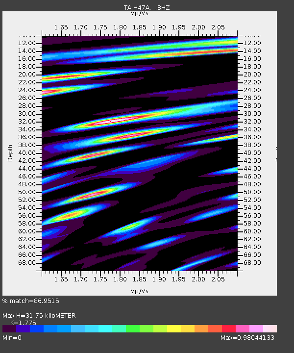
H47A Mio, MI, USA - Earthquake Result Viewer

Earthquake location: Rat Islands, Aleutian Islands
Earthquake latitude/longitude: 52.3/176.7
Earthquake time(UTC): 2014/06/24 (175) 03:15:36 GMT
Earthquake Depth: 4.0 km
Earthquake Magnitude: 6.3 MWB, 5.7 ML, 6.4 MWC, 6.6 MI
Earthquake Catalog/Contributor: NEIC PDE/NEIC COMCAT
Network: TA USArray Transportable Network (new EarthScope stations)
Station: H47A Mio, MI, USA
Lat/Lon: 44.60 N/84.21 W
Elevation: 356 m
Distance: 61.1 deg
Az: 53.654 deg
Baz: 316.123 deg
Ray Param: 0.061079312
Estimated Moho Depth: 31.75 km
Estimated Crust Vp/Vs: 1.77
Assumed Crust Vp: 6.483 km/s
Estimated Crust Vs: 3.652 km/s
Estimated Crust Poisson's Ratio: 0.27
Radial Match: 86.9515 %
Radial Bump: 400
Transverse Match: 68.87157 %
Transverse Bump: 400
SOD ConfigId: 739768
Insert Time: 2014-07-08 04:12:35.409 +0000
GWidth: 2.5
Max Bumps: 400
Tol: 0.001

Signal To Noise

ChannelStoNSTALTA
TA:H47A: :BHZ:20140624T03:25:20.874993Z5.13122229.214106E-71.7956943E-7
TA:H47A: :BHN:20140624T03:25:20.874993Z1.30468252.7013738E-72.0705221E-7
TA:H47A: :BHE:20140624T03:25:20.874993Z1.89647923.105126E-71.6373109E-7
Arrivals
Ps4.0 SECOND
PpPs13 SECOND
PsPs/PpSs17 SECOND