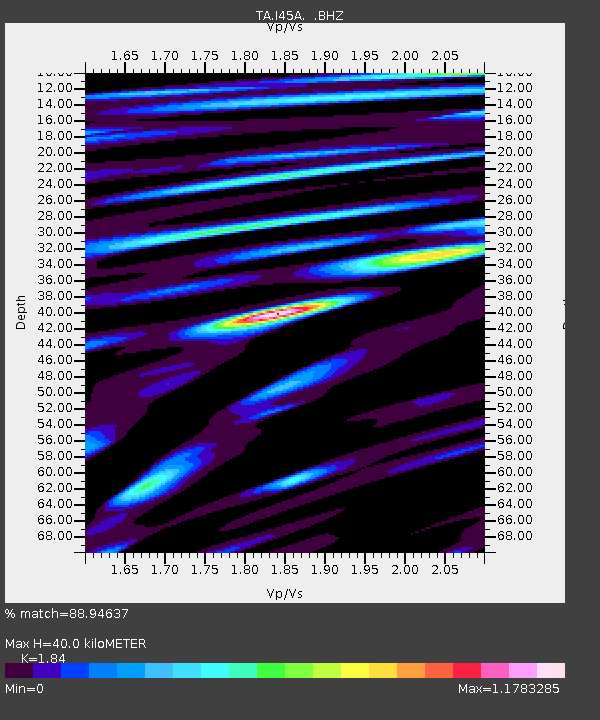
I45A Fountain, MI, USA - Earthquake Result Viewer
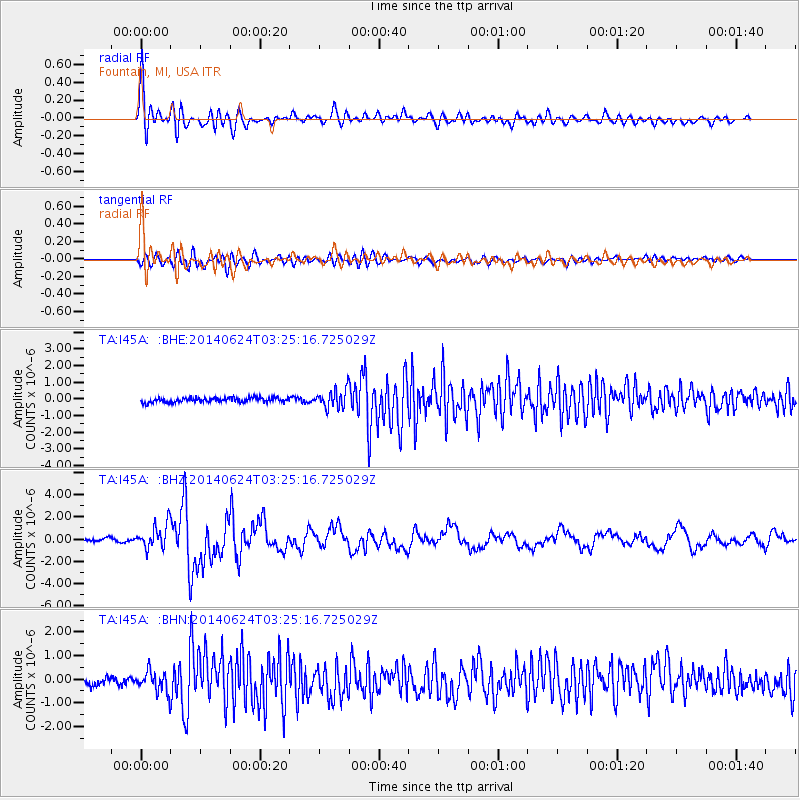
Earthquake location: Rat Islands, Aleutian Islands
Earthquake latitude/longitude: 52.3/176.7
Earthquake time(UTC): 2014/06/24 (175) 03:15:36 GMT
Earthquake Depth: 4.0 km
Earthquake Magnitude: 6.3 MWB, 5.7 ML, 6.4 MWC, 6.6 MI
Earthquake Catalog/Contributor: NEIC PDE/NEIC COMCAT
Network: TA USArray Transportable Network (new EarthScope stations)
Station: I45A Fountain, MI, USA
Lat/Lon: 44.04 N/86.23 W
Elevation: 215 m
Distance: 60.5 deg
Az: 55.299 deg
Baz: 315.512 deg
Ray Param: 0.061483473
Estimated Moho Depth: 40.0 km
Estimated Crust Vp/Vs: 1.84
Assumed Crust Vp: 6.53 km/s
Estimated Crust Vs: 3.549 km/s
Estimated Crust Poisson's Ratio: 0.29
Radial Match: 88.94637 %
Radial Bump: 400
Transverse Match: 74.54427 %
Transverse Bump: 400
SOD ConfigId: 739768
Insert Time: 2014-07-08 04:13:16.616 +0000
GWidth: 2.5
Max Bumps: 400
Tol: 0.001

Signal To Noise

ChannelStoNSTALTA
TA:I45A: :BHZ:20140624T03:25:16.725029Z6.0112551.1058178E-61.8395788E-7
TA:I45A: :BHN:20140624T03:25:16.725029Z2.48189234.4348442E-71.7868801E-7
TA:I45A: :BHE:20140624T03:25:16.725029Z3.89904215.409806E-71.3874705E-7
Arrivals
Ps5.4 SECOND
PpPs17 SECOND
PsPs/PpSs22 SECOND