You are here: Home > Network List > II - Global Seismograph Network (GSN - IRIS/IDA) Stations List
> Station WRAB Tennant Creek, NT, Australia > Earthquake Result Viewer
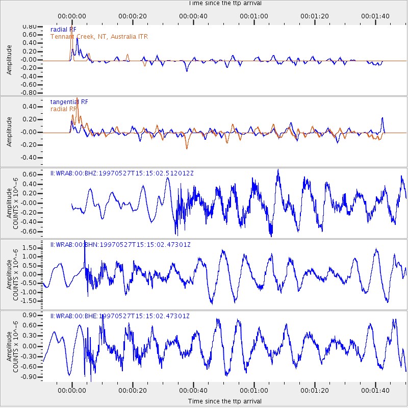
WRAB Tennant Creek, NT, Australia - Earthquake Result Viewer
*The percent match for this event was below the threshold and hence no stack was calculated.
| Earthquake location: |
Mariana Islands |
| Earthquake latitude/longitude: |
16.3/145.4 |
| Earthquake time(UTC): |
1997/05/27 (147) 15:09:03 GMT |
| Earthquake Depth: |
536 km |
| Earthquake Magnitude: |
5.5 MB, 5.6 UNKNOWN, 5.6 MW |
| Earthquake Catalog/Contributor: |
WHDF/NEIC |
|
| Network: |
II Global Seismograph Network (GSN - IRIS/IDA) |
| Station: |
WRAB Tennant Creek, NT, Australia |
| Lat/Lon: |
19.93 S/134.36 E |
| Elevation: |
366 m |
|
| Distance: |
37.6 deg |
| Az: |
197.224 deg |
| Baz: |
17.59 deg |
| Ray Param: |
$rayparam |
*The percent match for this event was below the threshold and hence was not used in the summary stack. |
|
| Radial Match: |
71.84011 % |
| Radial Bump: |
400 |
| Transverse Match: |
48.90048 % |
| Transverse Bump: |
400 |
| SOD ConfigId: |
4480 |
| Insert Time: |
2010-03-01 23:31:46.630 +0000 |
| GWidth: |
2.5 |
| Max Bumps: |
400 |
| Tol: |
0.001 |
|
Signal To Noise
| Channel | StoN | STA | LTA |
| II:WRAB:00:BHN:19970527T15:15:02.47301Z | 1.0243381 | 4.450095E-7 | 4.3443612E-7 |
| II:WRAB:00:BHE:19970527T15:15:02.47301Z | 1.7161596 | 4.884647E-7 | 2.8462665E-7 |
| II:WRAB:00:BHZ:19970527T15:15:02.512012Z | 2.1103284 | 3.2720627E-7 | 1.5504993E-7 |
| Arrivals |
| Ps | |
| PpPs | |
| PsPs/PpSs | |


