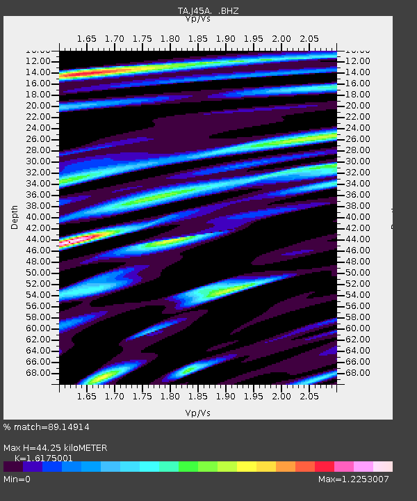
J45A Montague, MI, USA - Earthquake Result Viewer
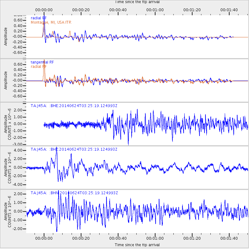
Earthquake location: Rat Islands, Aleutian Islands
Earthquake latitude/longitude: 52.3/176.7
Earthquake time(UTC): 2014/06/24 (175) 03:15:36 GMT
Earthquake Depth: 4.0 km
Earthquake Magnitude: 6.3 MWB, 5.7 ML, 6.4 MWC, 6.6 MI
Earthquake Catalog/Contributor: NEIC PDE/NEIC COMCAT
Network: TA USArray Transportable Network (new EarthScope stations)
Station: J45A Montague, MI, USA
Lat/Lon: 43.44 N/86.39 W
Elevation: 209 m
Distance: 60.9 deg
Az: 55.872 deg
Baz: 315.686 deg
Ray Param: 0.061251394
Estimated Moho Depth: 44.25 km
Estimated Crust Vp/Vs: 1.62
Assumed Crust Vp: 6.483 km/s
Estimated Crust Vs: 4.008 km/s
Estimated Crust Poisson's Ratio: 0.19
Radial Match: 89.14914 %
Radial Bump: 400
Transverse Match: 64.79583 %
Transverse Bump: 400
SOD ConfigId: 739768
Insert Time: 2014-07-08 04:14:12.494 +0000
GWidth: 2.5
Max Bumps: 400
Tol: 0.001

Signal To Noise

ChannelStoNSTALTA
TA:J45A: :BHZ:20140624T03:25:19.124993Z4.3157091.0436181E-62.4181847E-7
TA:J45A: :BHN:20140624T03:25:19.124993Z1.59522914.4733014E-72.8041748E-7
TA:J45A: :BHE:20140624T03:25:19.124993Z2.35607865.18836E-72.2021167E-7
Arrivals
Ps4.4 SECOND
PpPs17 SECOND
PsPs/PpSs21 SECOND