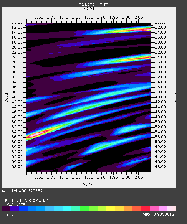
K22A Casper, WY, USA - Earthquake Result Viewer

Earthquake location: Rat Islands, Aleutian Islands
Earthquake latitude/longitude: 52.3/176.7
Earthquake time(UTC): 2014/06/24 (175) 03:15:36 GMT
Earthquake Depth: 4.0 km
Earthquake Magnitude: 6.3 MWB, 5.7 ML, 6.4 MWC, 6.6 MI
Earthquake Catalog/Contributor: NEIC PDE/NEIC COMCAT
Network: TA USArray Transportable Network (new EarthScope stations)
Station: K22A Casper, WY, USA
Lat/Lon: 42.65 N/106.52 W
Elevation: 1686 m
Distance: 50.5 deg
Az: 68.58 deg
Baz: 309.13 deg
Ray Param: 0.06804292
Estimated Moho Depth: 54.75 km
Estimated Crust Vp/Vs: 1.64
Assumed Crust Vp: 6.178 km/s
Estimated Crust Vs: 3.773 km/s
Estimated Crust Poisson's Ratio: 0.20
Radial Match: 90.643654 %
Radial Bump: 400
Transverse Match: 67.676254 %
Transverse Bump: 400
SOD ConfigId: 739768
Insert Time: 2014-07-08 04:14:50.452 +0000
GWidth: 2.5
Max Bumps: 400
Tol: 0.001

Signal To Noise

ChannelStoNSTALTA
TA:K22A: :BHZ:20140624T03:24:04.550011Z8.4637085.490531E-76.487146E-8
TA:K22A: :BHN:20140624T03:24:04.550011Z3.02712772.2416519E-77.40521E-8
TA:K22A: :BHE:20140624T03:24:04.550011Z1.65819511.8925128E-71.14130884E-7
Arrivals
Ps6.0 SECOND
PpPs22 SECOND
PsPs/PpSs28 SECOND