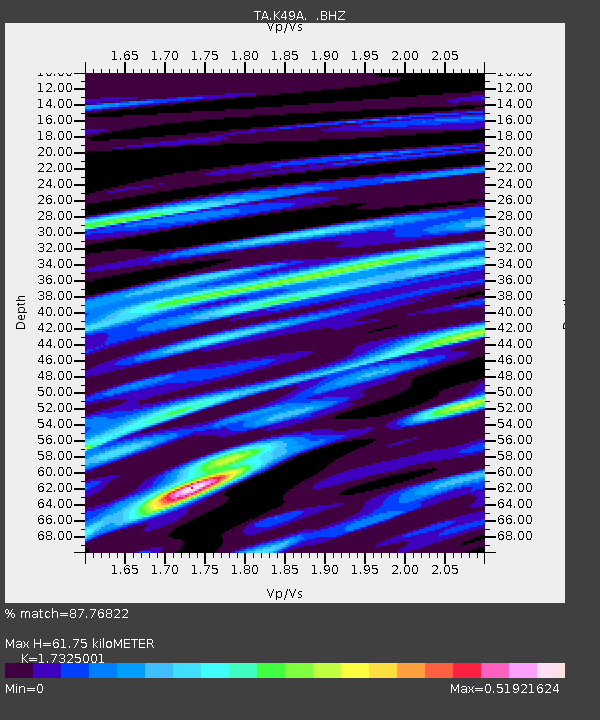
K49A Clarkson, MI, USA - Earthquake Result Viewer

Earthquake location: Rat Islands, Aleutian Islands
Earthquake latitude/longitude: 52.3/176.7
Earthquake time(UTC): 2014/06/24 (175) 03:15:36 GMT
Earthquake Depth: 4.0 km
Earthquake Magnitude: 6.3 MWB, 5.7 ML, 6.4 MWC, 6.6 MI
Earthquake Catalog/Contributor: NEIC PDE/NEIC COMCAT
Network: TA USArray Transportable Network (new EarthScope stations)
Station: K49A Clarkson, MI, USA
Lat/Lon: 42.78 N/83.46 W
Elevation: 336 m
Distance: 62.8 deg
Az: 54.618 deg
Baz: 317.092 deg
Ray Param: 0.05997916
Estimated Moho Depth: 61.75 km
Estimated Crust Vp/Vs: 1.73
Assumed Crust Vp: 6.483 km/s
Estimated Crust Vs: 3.742 km/s
Estimated Crust Poisson's Ratio: 0.25
Radial Match: 87.76822 %
Radial Bump: 392
Transverse Match: 81.44744 %
Transverse Bump: 400
SOD ConfigId: 739768
Insert Time: 2014-07-08 04:14:58.211 +0000
GWidth: 2.5
Max Bumps: 400
Tol: 0.001

Signal To Noise

ChannelStoNSTALTA
TA:K49A: :BHZ:20140624T03:25:32.249993Z5.3974321.0148268E-61.8802031E-7
TA:K49A: :BHN:20140624T03:25:32.249993Z1.67190773.0012944E-71.7951317E-7
TA:K49A: :BHE:20140624T03:25:32.249993Z2.3610553.9801316E-71.6857429E-7
Arrivals
Ps7.3 SECOND
PpPs25 SECOND
PsPs/PpSs32 SECOND