You are here: Home > Network List > II - Global Seismograph Network (GSN - IRIS/IDA) Stations List
> Station WRAB Tennant Creek, NT, Australia > Earthquake Result Viewer
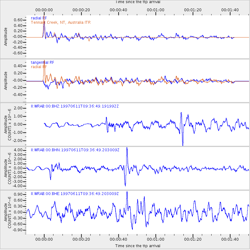
WRAB Tennant Creek, NT, Australia - Earthquake Result Viewer
*The percent match for this event was below the threshold and hence no stack was calculated.
| Earthquake location: |
South Of Fiji Islands |
| Earthquake latitude/longitude: |
-24.0/-177.5 |
| Earthquake time(UTC): |
1997/06/11 (162) 09:29:23 GMT |
| Earthquake Depth: |
164 km |
| Earthquake Magnitude: |
5.9 UNKNOWN, 5.4 MB, 5.5 MB |
| Earthquake Catalog/Contributor: |
WHDF/NEIC |
|
| Network: |
II Global Seismograph Network (GSN - IRIS/IDA) |
| Station: |
WRAB Tennant Creek, NT, Australia |
| Lat/Lon: |
19.93 S/134.36 E |
| Elevation: |
366 m |
|
| Distance: |
44.7 deg |
| Az: |
265.401 deg |
| Baz: |
104.262 deg |
| Ray Param: |
$rayparam |
*The percent match for this event was below the threshold and hence was not used in the summary stack. |
|
| Radial Match: |
60.016716 % |
| Radial Bump: |
400 |
| Transverse Match: |
66.7222 % |
| Transverse Bump: |
400 |
| SOD ConfigId: |
4480 |
| Insert Time: |
2010-03-01 23:31:52.515 +0000 |
| GWidth: |
2.5 |
| Max Bumps: |
400 |
| Tol: |
0.001 |
|
Signal To Noise
| Channel | StoN | STA | LTA |
| II:WRAB:00:BHN:19970611T09:36:49.203009Z | 3.4872017 | 7.3182804E-7 | 2.0986111E-7 |
| II:WRAB:00:BHE:19970611T09:36:49.203009Z | 1.6577946 | 2.1781709E-7 | 1.3138967E-7 |
| II:WRAB:00:BHZ:19970611T09:36:49.191992Z | 2.4891293 | 3.8415365E-7 | 1.5433254E-7 |
| Arrivals |
| Ps | |
| PpPs | |
| PsPs/PpSs | |


