You are here: Home > Network List > TA - USArray Transportable Network (new EarthScope stations) Stations List
> Station L58A Harry Jones Memorial, Binghamton, NY, USA > Earthquake Result Viewer
L58A Harry Jones Memorial, Binghamton, NY, USA - Earthquake Result Viewer
| Earthquake location: |
Rat Islands, Aleutian Islands |
| Earthquake latitude/longitude: |
52.3/176.7 |
| Earthquake time(UTC): |
2014/06/24 (175) 03:15:36 GMT |
| Earthquake Depth: |
4.0 km |
| Earthquake Magnitude: |
6.3 MWB, 5.7 ML, 6.4 MWC, 6.6 MI |
| Earthquake Catalog/Contributor: |
NEIC PDE/NEIC COMCAT |
|
| Network: |
TA USArray Transportable Network (new EarthScope stations) |
| Station: |
L58A Harry Jones Memorial, Binghamton, NY, USA |
| Lat/Lon: |
42.04 N/75.85 W |
| Elevation: |
447 m |
|
| Distance: |
67.1 deg |
| Az: |
50.481 deg |
| Baz: |
320.456 deg |
| Ray Param: |
0.057186626 |
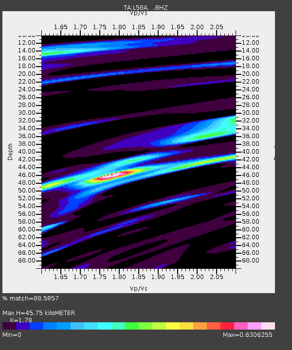
| Estimated Moho Depth: |
45.75 km |
| Estimated Crust Vp/Vs: |
1.78 |
| Assumed Crust Vp: |
6.419 km/s |
| Estimated Crust Vs: |
3.606 km/s |
| Estimated Crust Poisson's Ratio: |
0.27 |
|
| Radial Match: |
88.5957 % |
| Radial Bump: |
400 |
| Transverse Match: |
77.21221 % |
| Transverse Bump: |
400 |
| SOD ConfigId: |
739768 |
| Insert Time: |
2014-07-08 04:16:08.360 +0000 |
| GWidth: |
2.5 |
| Max Bumps: |
400 |
| Tol: |
0.001 |
|
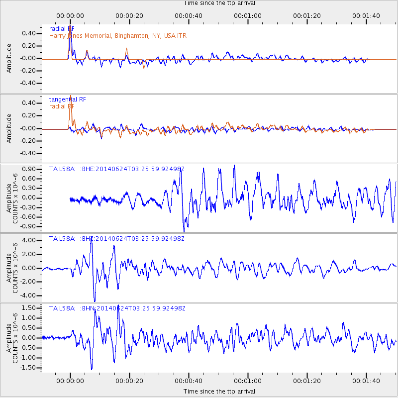
Signal To Noise
| Channel | StoN | STA | LTA |
| TA:L58A: :BHZ:20140624T03:25:59.92498Z | 3.780552 | 8.1800863E-7 | 2.1637281E-7 |
| TA:L58A: :BHN:20140624T03:25:59.92498Z | 2.460962 | 2.68714E-7 | 1.0919063E-7 |
| TA:L58A: :BHE:20140624T03:25:59.92498Z | 2.2289789 | 2.1776775E-7 | 9.769843E-8 |
| Arrivals |
| Ps | 5.8 SECOND |
| PpPs | 19 SECOND |
| PsPs/PpSs | 25 SECOND |


