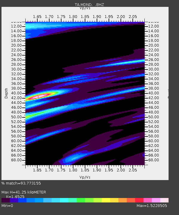
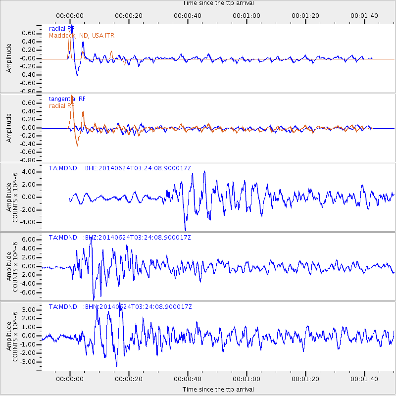
MDND Maddock, ND, USA - Earthquake Result Viewer

Earthquake location: Rat Islands, Aleutian Islands
Earthquake latitude/longitude: 52.3/176.7
Earthquake time(UTC): 2014/06/24 (175) 03:15:36 GMT
Earthquake Depth: 4.0 km
Earthquake Magnitude: 6.3 MWB, 5.7 ML, 6.4 MWC, 6.6 MI
Earthquake Catalog/Contributor: NEIC PDE/NEIC COMCAT
Network: TA USArray Transportable Network (new EarthScope stations)
Station: MDND Maddock, ND, USA
Lat/Lon: 47.85 N/99.60 W
Elevation: 479 m
Distance: 51.1 deg
Az: 59.401 deg
Baz: 308.225 deg
Ray Param: 0.067665845
Estimated Moho Depth: 41.25 km
Estimated Crust Vp/Vs: 1.65
Assumed Crust Vp: 6.53 km/s
Estimated Crust Vs: 3.952 km/s
Estimated Crust Poisson's Ratio: 0.21
Radial Match: 93.773155 %
Radial Bump: 400
Transverse Match: 82.51909 %
Transverse Bump: 400
SOD ConfigId: 739768
Insert Time: 2014-07-08 04:17:23.446 +0000
GWidth: 2.5
Max Bumps: 400
Tol: 0.001

Signal To Noise

ChannelStoNSTALTA
TA:MDND: :BHZ:20140624T03:24:08.900017Z13.0782151.7137643E-61.3103961E-7
TA:MDND: :BHN:20140624T03:24:08.900017Z0.96899733.3108014E-73.4167294E-7
TA:MDND: :BHE:20140624T03:24:08.900017Z1.05526894.555906E-74.3172938E-7
Arrivals
Ps4.4 SECOND
PpPs16 SECOND
PsPs/PpSs20 SECOND