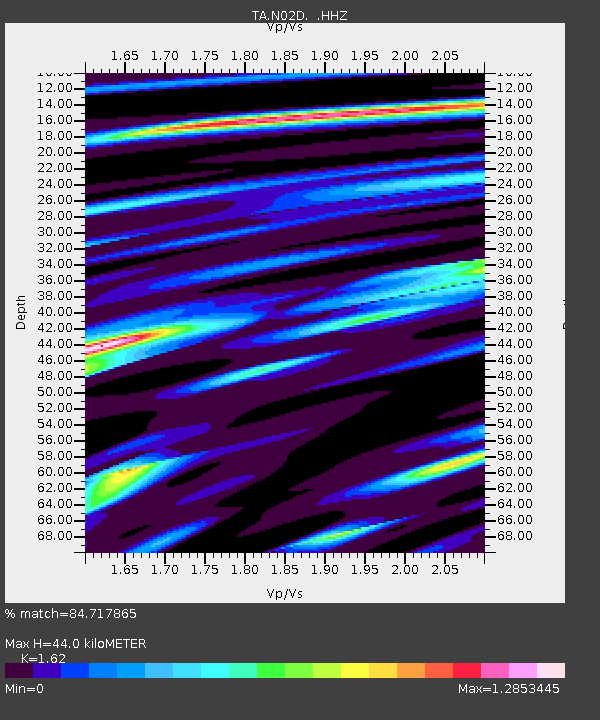
N02D Trinity Center, CA, USA - Earthquake Result Viewer
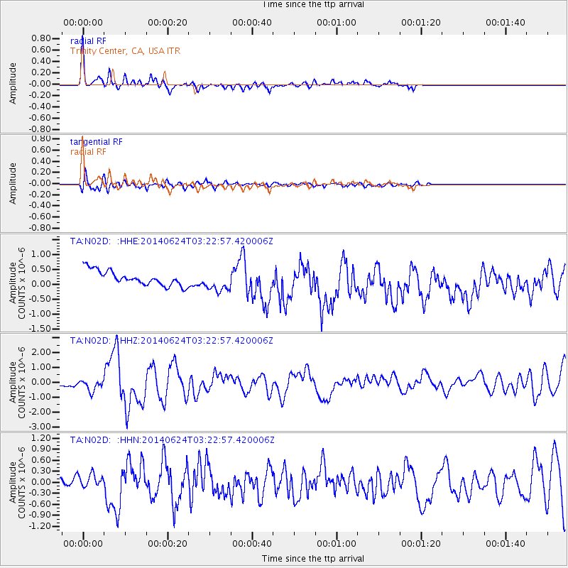
Earthquake location: Rat Islands, Aleutian Islands
Earthquake latitude/longitude: 52.3/176.7
Earthquake time(UTC): 2014/06/24 (175) 03:15:36 GMT
Earthquake Depth: 4.0 km
Earthquake Magnitude: 6.3 MWB, 5.7 ML, 6.4 MWC, 6.6 MI
Earthquake Catalog/Contributor: NEIC PDE/NEIC COMCAT
Network: TA USArray Transportable Network (new EarthScope stations)
Station: N02D Trinity Center, CA, USA
Lat/Lon: 40.97 N/122.71 W
Elevation: 937 m
Distance: 41.9 deg
Az: 80.683 deg
Baz: 306.756 deg
Ray Param: 0.07348921
Estimated Moho Depth: 44.0 km
Estimated Crust Vp/Vs: 1.62
Assumed Crust Vp: 6.566 km/s
Estimated Crust Vs: 4.053 km/s
Estimated Crust Poisson's Ratio: 0.19
Radial Match: 84.717865 %
Radial Bump: 356
Transverse Match: 73.057495 %
Transverse Bump: 400
SOD ConfigId: 739768
Insert Time: 2014-07-08 04:17:31.682 +0000
GWidth: 2.5
Max Bumps: 400
Tol: 0.001

Signal To Noise

ChannelStoNSTALTA
TA:N02D: :HHZ:20140624T03:22:57.420006Z2.5884714.0817864E-71.5769103E-7
TA:N02D: :HHN:20140624T03:22:57.420006Z1.11969891.8739685E-71.6736361E-7
TA:N02D: :HHE:20140624T03:22:57.420006Z1.47929063.6188194E-72.4463208E-7
Arrivals
Ps4.5 SECOND
PpPs16 SECOND
PsPs/PpSs21 SECOND