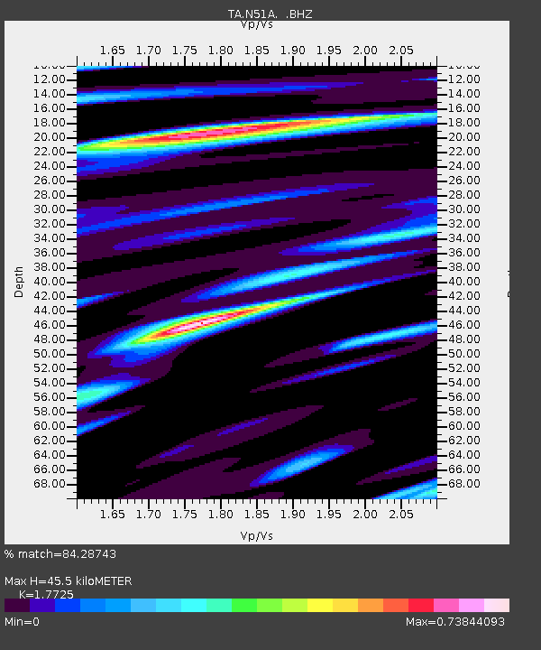
N51A Ashland, OH, USA - Earthquake Result Viewer

Earthquake location: Rat Islands, Aleutian Islands
Earthquake latitude/longitude: 52.3/176.7
Earthquake time(UTC): 2014/06/24 (175) 03:15:36 GMT
Earthquake Depth: 4.0 km
Earthquake Magnitude: 6.3 MWB, 5.7 ML, 6.4 MWC, 6.6 MI
Earthquake Catalog/Contributor: NEIC PDE/NEIC COMCAT
Network: TA USArray Transportable Network (new EarthScope stations)
Station: N51A Ashland, OH, USA
Lat/Lon: 40.92 N/82.37 W
Elevation: 343 m
Distance: 64.8 deg
Az: 55.353 deg
Baz: 318.136 deg
Ray Param: 0.058729675
Estimated Moho Depth: 45.5 km
Estimated Crust Vp/Vs: 1.77
Assumed Crust Vp: 6.498 km/s
Estimated Crust Vs: 3.666 km/s
Estimated Crust Poisson's Ratio: 0.27
Radial Match: 84.28743 %
Radial Bump: 400
Transverse Match: 71.20541 %
Transverse Bump: 400
SOD ConfigId: 739768
Insert Time: 2014-07-08 04:17:41.096 +0000
GWidth: 2.5
Max Bumps: 400
Tol: 0.001

Signal To Noise

ChannelStoNSTALTA
TA:N51A: :BHZ:20140624T03:25:44.874993Z6.67656858.0003036E-71.1982658E-7
TA:N51A: :BHN:20140624T03:25:44.874993Z2.09965253.106512E-71.4795361E-7
TA:N51A: :BHE:20140624T03:25:44.874993Z1.77672422.6621373E-71.4983402E-7
Arrivals
Ps5.6 SECOND
PpPs19 SECOND
PsPs/PpSs24 SECOND