O60A Telford, PA, USA - Earthquake Result Viewer
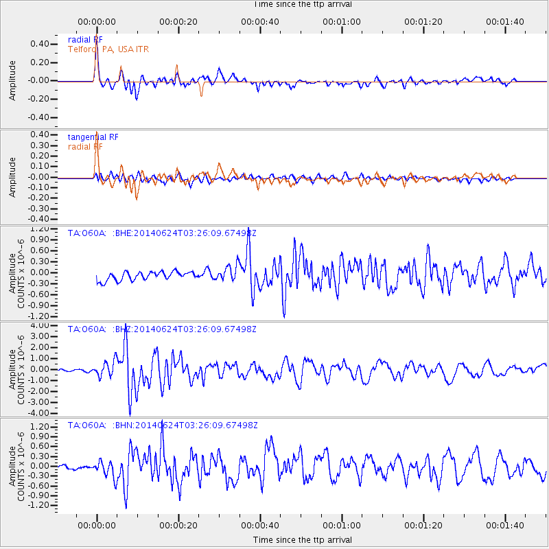
Earthquake location: Rat Islands, Aleutian Islands
Earthquake latitude/longitude: 52.3/176.7
Earthquake time(UTC): 2014/06/24 (175) 03:15:36 GMT
Earthquake Depth: 4.0 km
Earthquake Magnitude: 6.3 MWB, 5.7 ML, 6.4 MWC, 6.6 MI
Earthquake Catalog/Contributor: NEIC PDE/NEIC COMCAT
Network: TA USArray Transportable Network (new EarthScope stations)
Station: O60A Telford, PA, USA
Lat/Lon: 40.32 N/75.40 W
Elevation: 70 m
Distance: 68.7 deg
Az: 51.378 deg
Baz: 321.085 deg
Ray Param: 0.056175392
Estimated Moho Depth: 62.75 km
Estimated Crust Vp/Vs: 2.09
Assumed Crust Vp: 6.283 km/s
Estimated Crust Vs: 3.003 km/s
Estimated Crust Poisson's Ratio: 0.35
Radial Match: 88.314606 %
Radial Bump: 400
Transverse Match: 68.58082 %
Transverse Bump: 400
SOD ConfigId: 739768
Insert Time: 2014-07-08 04:19:22.460 +0000
GWidth: 2.5
Max Bumps: 400
Tol: 0.001

Signal To Noise

ChannelStoNSTALTA
TA:O60A: :BHZ:20140624T03:26:09.67498Z7.18735557.1542166E-79.953892E-8
TA:O60A: :BHN:20140624T03:26:09.67498Z2.43864872.704591E-71.10905326E-7
TA:O60A: :BHE:20140624T03:26:09.67498Z1.95245242.2517406E-71.1532884E-7
Arrivals
Ps11 SECOND
PpPs30 SECOND
PsPs/PpSs41 SECOND