You are here: Home > Network List > II - Global Seismograph Network (GSN - IRIS/IDA) Stations List
> Station WRAB Tennant Creek, NT, Australia > Earthquake Result Viewer
WRAB Tennant Creek, NT, Australia - Earthquake Result Viewer
*The percent match for this event was below the threshold and hence no stack was calculated.
| Earthquake location: |
Southern Sumatra, Indonesia |
| Earthquake latitude/longitude: |
-4.8/102.9 |
| Earthquake time(UTC): |
2009/07/26 (207) 23:10:24 GMT |
| Earthquake Depth: |
47 km |
| Earthquake Magnitude: |
6.0 MB, 5.7 MW, 5.6 MW |
| Earthquake Catalog/Contributor: |
WHDF/NEIC |
|
| Network: |
II Global Seismograph Network (GSN - IRIS/IDA) |
| Station: |
WRAB Tennant Creek, NT, Australia |
| Lat/Lon: |
19.93 S/134.36 E |
| Elevation: |
366 m |
|
| Distance: |
34.1 deg |
| Az: |
118.907 deg |
| Baz: |
291.989 deg |
| Ray Param: |
$rayparam |
*The percent match for this event was below the threshold and hence was not used in the summary stack. |
|
| Radial Match: |
83.86146 % |
| Radial Bump: |
400 |
| Transverse Match: |
54.811367 % |
| Transverse Bump: |
400 |
| SOD ConfigId: |
2648 |
| Insert Time: |
2010-03-01 23:32:06.075 +0000 |
| GWidth: |
2.5 |
| Max Bumps: |
400 |
| Tol: |
0.001 |
|
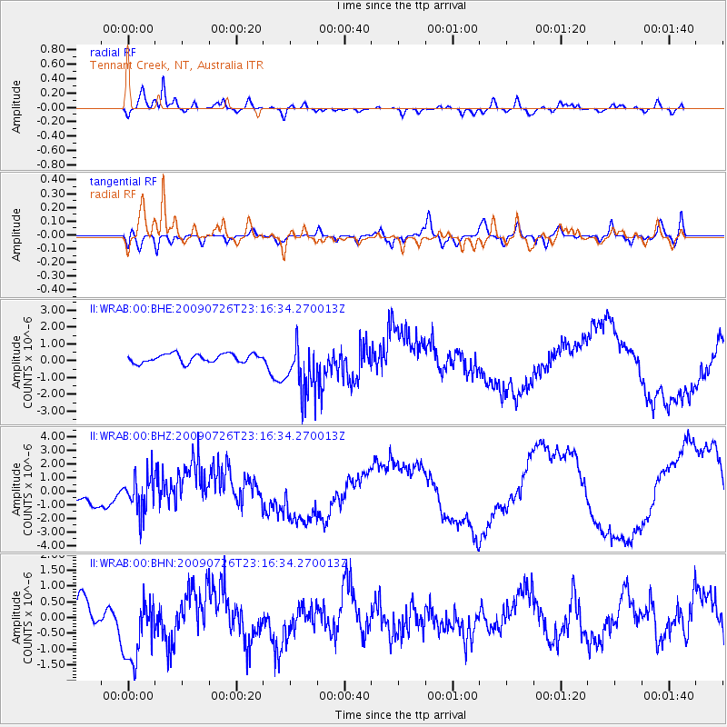
Signal To Noise
| Channel | StoN | STA | LTA |
| II:WRAB:00:BHZ:20090726T23:16:34.270013Z | 2.0542445 | 1.317488E-6 | 6.413491E-7 |
| II:WRAB:00:BHN:20090726T23:16:34.270013Z | 1.3279414 | 1.0444502E-6 | 7.865183E-7 |
| II:WRAB:00:BHE:20090726T23:16:34.270013Z | 6.3593116 | 1.6149095E-6 | 2.5394408E-7 |
| Arrivals |
| Ps | |
| PpPs | |
| PsPs/PpSs | |


