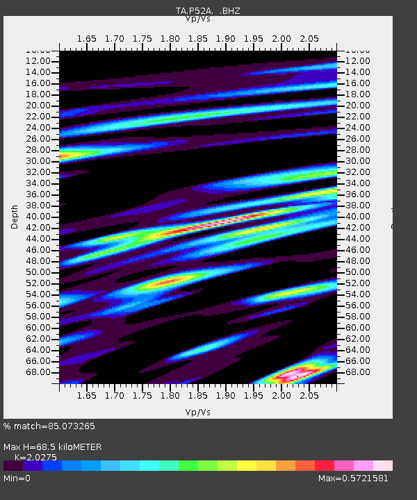
P52A Corning, OH, USA - Earthquake Result Viewer

Earthquake location: Rat Islands, Aleutian Islands
Earthquake latitude/longitude: 52.3/176.7
Earthquake time(UTC): 2014/06/24 (175) 03:15:36 GMT
Earthquake Depth: 4.0 km
Earthquake Magnitude: 6.3 MWB, 5.7 ML, 6.4 MWC, 6.6 MI
Earthquake Catalog/Contributor: NEIC PDE/NEIC COMCAT
Network: TA USArray Transportable Network (new EarthScope stations)
Station: P52A Corning, OH, USA
Lat/Lon: 39.63 N/82.13 W
Elevation: 293 m
Distance: 65.8 deg
Az: 56.139 deg
Baz: 318.62 deg
Ray Param: 0.058020335
Estimated Moho Depth: 68.5 km
Estimated Crust Vp/Vs: 2.03
Assumed Crust Vp: 6.232 km/s
Estimated Crust Vs: 3.074 km/s
Estimated Crust Poisson's Ratio: 0.34
Radial Match: 85.073265 %
Radial Bump: 400
Transverse Match: 70.07726 %
Transverse Bump: 400
SOD ConfigId: 739768
Insert Time: 2014-07-08 04:19:39.449 +0000
GWidth: 2.5
Max Bumps: 400
Tol: 0.001

Signal To Noise

ChannelStoNSTALTA
TA:P52A: :BHZ:20140624T03:25:51.874993Z5.08399156.1694493E-71.2135051E-7
TA:P52A: :BHN:20140624T03:25:51.874993Z2.5227292.4780468E-79.822882E-8
TA:P52A: :BHE:20140624T03:25:51.874993Z1.63546662.1958064E-71.3426177E-7
Arrivals
Ps12 SECOND
PpPs32 SECOND
PsPs/PpSs44 SECOND