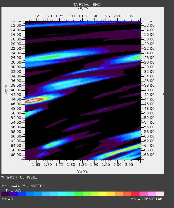
P59A Jarrettsville, MD, USA - Earthquake Result Viewer
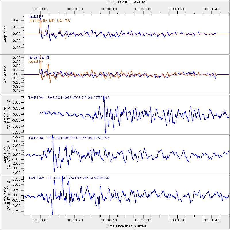
Earthquake location: Rat Islands, Aleutian Islands
Earthquake latitude/longitude: 52.3/176.7
Earthquake time(UTC): 2014/06/24 (175) 03:15:36 GMT
Earthquake Depth: 4.0 km
Earthquake Magnitude: 6.3 MWB, 5.7 ML, 6.4 MWC, 6.6 MI
Earthquake Catalog/Contributor: NEIC PDE/NEIC COMCAT
Network: TA USArray Transportable Network (new EarthScope stations)
Station: P59A Jarrettsville, MD, USA
Lat/Lon: 39.61 N/76.43 W
Elevation: 157 m
Distance: 68.7 deg
Az: 52.515 deg
Baz: 320.841 deg
Ray Param: 0.0561417
Estimated Moho Depth: 44.25 km
Estimated Crust Vp/Vs: 1.63
Assumed Crust Vp: 6.419 km/s
Estimated Crust Vs: 3.926 km/s
Estimated Crust Poisson's Ratio: 0.20
Radial Match: 80.49561 %
Radial Bump: 400
Transverse Match: 66.51576 %
Transverse Bump: 400
SOD ConfigId: 739768
Insert Time: 2014-07-08 04:20:04.295 +0000
GWidth: 2.5
Max Bumps: 400
Tol: 0.001

Signal To Noise

ChannelStoNSTALTA
TA:P59A: :BHZ:20140624T03:26:09.975029Z6.9494856.829641E-79.827551E-8
TA:P59A: :BHN:20140624T03:26:09.975029Z3.14944313.386641E-71.0753143E-7
TA:P59A: :BHE:20140624T03:26:09.975029Z2.94253373.1221734E-71.0610493E-7
Arrivals
Ps4.6 SECOND
PpPs17 SECOND
PsPs/PpSs22 SECOND