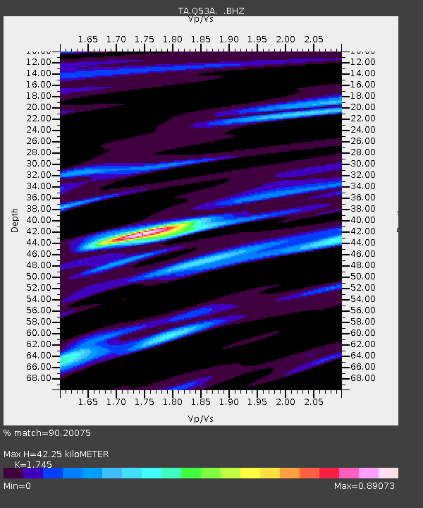
Q53A Leroy, WV, USA - Earthquake Result Viewer

Earthquake location: Rat Islands, Aleutian Islands
Earthquake latitude/longitude: 52.3/176.7
Earthquake time(UTC): 2014/06/24 (175) 03:15:36 GMT
Earthquake Depth: 4.0 km
Earthquake Magnitude: 6.3 MWB, 5.7 ML, 6.4 MWC, 6.6 MI
Earthquake Catalog/Contributor: NEIC PDE/NEIC COMCAT
Network: TA USArray Transportable Network (new EarthScope stations)
Station: Q53A Leroy, WV, USA
Lat/Lon: 38.86 N/81.53 W
Elevation: 310 m
Distance: 66.7 deg
Az: 56.307 deg
Baz: 319.071 deg
Ray Param: 0.05743286
Estimated Moho Depth: 42.25 km
Estimated Crust Vp/Vs: 1.75
Assumed Crust Vp: 6.207 km/s
Estimated Crust Vs: 3.557 km/s
Estimated Crust Poisson's Ratio: 0.26
Radial Match: 90.20075 %
Radial Bump: 400
Transverse Match: 72.742905 %
Transverse Bump: 400
SOD ConfigId: 739768
Insert Time: 2014-07-08 04:20:21.447 +0000
GWidth: 2.5
Max Bumps: 400
Tol: 0.001

Signal To Noise

ChannelStoNSTALTA
TA:Q53A: :BHZ:20140624T03:25:57.575005Z6.78194678.111813E-71.1960893E-7
TA:Q53A: :BHN:20140624T03:25:57.575005Z2.31784652.652157E-71.1442332E-7
TA:Q53A: :BHE:20140624T03:25:57.575005Z1.59085071.6477912E-71.03579254E-7
Arrivals
Ps5.3 SECOND
PpPs18 SECOND
PsPs/PpSs23 SECOND