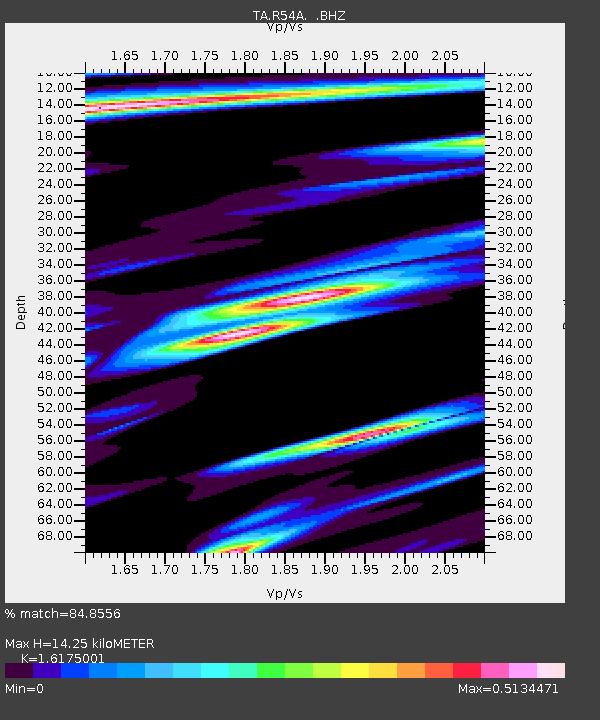
R54A Victor, WV, USA - Earthquake Result Viewer

Earthquake location: Rat Islands, Aleutian Islands
Earthquake latitude/longitude: 52.3/176.7
Earthquake time(UTC): 2014/06/24 (175) 03:15:36 GMT
Earthquake Depth: 4.0 km
Earthquake Magnitude: 6.3 MWB, 5.7 ML, 6.4 MWC, 6.6 MI
Earthquake Catalog/Contributor: NEIC PDE/NEIC COMCAT
Network: TA USArray Transportable Network (new EarthScope stations)
Station: R54A Victor, WV, USA
Lat/Lon: 38.18 N/80.99 W
Elevation: 512 m
Distance: 67.5 deg
Az: 56.442 deg
Baz: 319.454 deg
Ray Param: 0.05691534
Estimated Moho Depth: 14.25 km
Estimated Crust Vp/Vs: 1.62
Assumed Crust Vp: 6.207 km/s
Estimated Crust Vs: 3.837 km/s
Estimated Crust Poisson's Ratio: 0.19
Radial Match: 84.8556 %
Radial Bump: 400
Transverse Match: 67.21014 %
Transverse Bump: 400
SOD ConfigId: 739768
Insert Time: 2014-07-08 04:20:55.425 +0000
GWidth: 2.5
Max Bumps: 400
Tol: 0.001

Signal To Noise

ChannelStoNSTALTA
TA:R54A: :BHZ:20140624T03:26:02.575005Z6.56605348.156005E-71.2421472E-7
TA:R54A: :BHN:20140624T03:26:02.575005Z2.3395023.1830993E-71.3605884E-7
TA:R54A: :BHE:20140624T03:26:02.575005Z1.71582332.0215667E-71.17819056E-7
Arrivals
Ps1.5 SECOND
PpPs5.8 SECOND
PsPs/PpSs7.2 SECOND