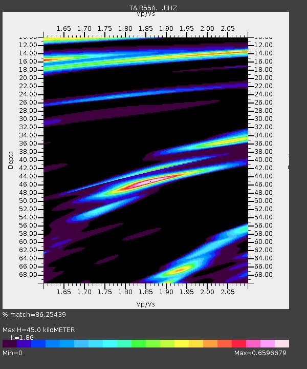
R55A Marlinton, WV, USA - Earthquake Result Viewer

Earthquake location: Rat Islands, Aleutian Islands
Earthquake latitude/longitude: 52.3/176.7
Earthquake time(UTC): 2014/06/24 (175) 03:15:36 GMT
Earthquake Depth: 4.0 km
Earthquake Magnitude: 6.3 MWB, 5.7 ML, 6.4 MWC, 6.6 MI
Earthquake Catalog/Contributor: NEIC PDE/NEIC COMCAT
Network: TA USArray Transportable Network (new EarthScope stations)
Station: R55A Marlinton, WV, USA
Lat/Lon: 38.28 N/80.12 W
Elevation: 833 m
Distance: 67.9 deg
Az: 55.806 deg
Baz: 319.75 deg
Ray Param: 0.056675896
Estimated Moho Depth: 45.0 km
Estimated Crust Vp/Vs: 1.86
Assumed Crust Vp: 6.207 km/s
Estimated Crust Vs: 3.337 km/s
Estimated Crust Poisson's Ratio: 0.30
Radial Match: 86.25439 %
Radial Bump: 400
Transverse Match: 71.771935 %
Transverse Bump: 400
SOD ConfigId: 739768
Insert Time: 2014-07-08 04:21:03.561 +0000
GWidth: 2.5
Max Bumps: 400
Tol: 0.001

Signal To Noise

ChannelStoNSTALTA
TA:R55A: :BHZ:20140624T03:26:04.874993Z4.53970865.721916E-71.2604147E-7
TA:R55A: :BHN:20140624T03:26:04.874993Z1.39376081.620402E-71.1626112E-7
TA:R55A: :BHE:20140624T03:26:04.874993Z1.62299251.2949707E-77.978907E-8
Arrivals
Ps6.5 SECOND
PpPs20 SECOND
PsPs/PpSs26 SECOND