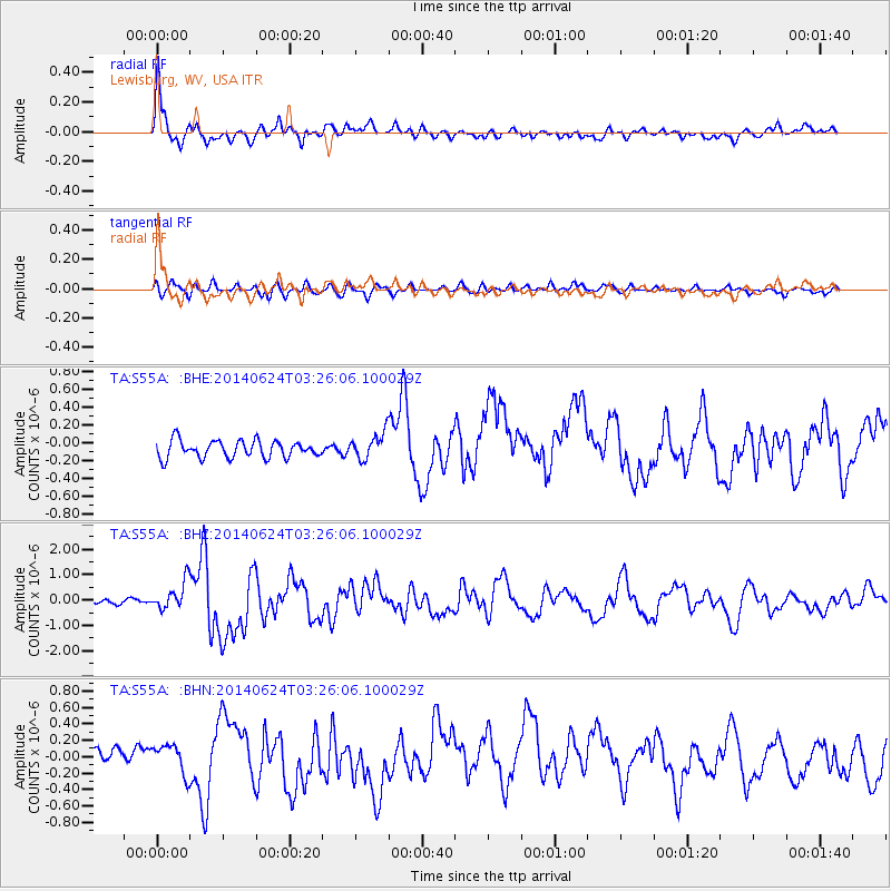
S55A Lewisburg, WV, USA - Earthquake Result Viewer
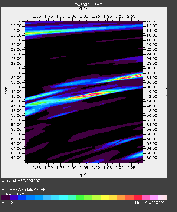
Earthquake location: Rat Islands, Aleutian Islands
Earthquake latitude/longitude: 52.3/176.7
Earthquake time(UTC): 2014/06/24 (175) 03:15:36 GMT
Earthquake Depth: 4.0 km
Earthquake Magnitude: 6.3 MWB, 5.7 ML, 6.4 MWC, 6.6 MI
Earthquake Catalog/Contributor: NEIC PDE/NEIC COMCAT
Network: TA USArray Transportable Network (new EarthScope stations)
Station: S55A Lewisburg, WV, USA
Lat/Lon: 37.77 N/80.50 W
Elevation: 647 m
Distance: 68.1 deg
Az: 56.409 deg
Baz: 319.742 deg
Ray Param: 0.056549516
Estimated Moho Depth: 32.75 km
Estimated Crust Vp/Vs: 2.09
Assumed Crust Vp: 6.159 km/s
Estimated Crust Vs: 2.95 km/s
Estimated Crust Poisson's Ratio: 0.35
Radial Match: 87.095055 %
Radial Bump: 354
Transverse Match: 73.161354 %
Transverse Bump: 400
SOD ConfigId: 739768
Insert Time: 2014-07-08 04:21:30.438 +0000
GWidth: 2.5
Max Bumps: 400
Tol: 0.001

Signal To Noise

ChannelStoNSTALTA
TA:S55A: :BHZ:20140624T03:26:06.100029Z6.5683925.737115E-78.734428E-8
TA:S55A: :BHN:20140624T03:26:06.100029Z2.1303431.7575572E-78.250114E-8
TA:S55A: :BHE:20140624T03:26:06.100029Z1.5077021.4370576E-79.5314434E-8
Arrivals
Ps6.0 SECOND
PpPs16 SECOND
PsPs/PpSs22 SECOND