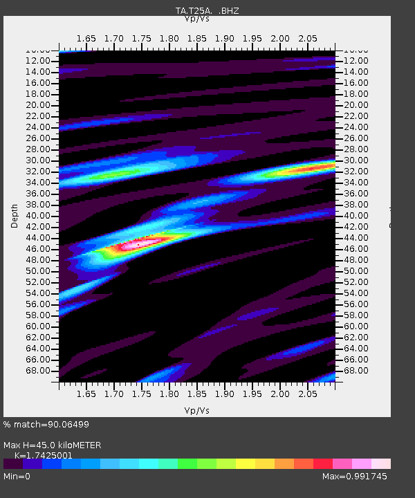
T25A Trinidad, CO, USA - Earthquake Result Viewer
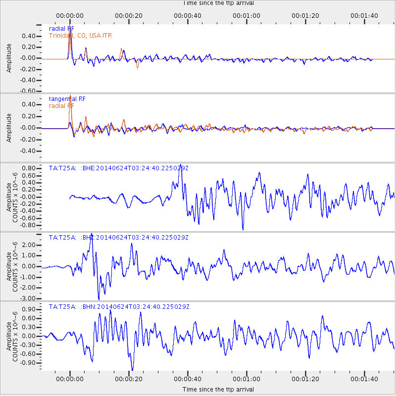
Earthquake location: Rat Islands, Aleutian Islands
Earthquake latitude/longitude: 52.3/176.7
Earthquake time(UTC): 2014/06/24 (175) 03:15:36 GMT
Earthquake Depth: 4.0 km
Earthquake Magnitude: 6.3 MWB, 5.7 ML, 6.4 MWC, 6.6 MI
Earthquake Catalog/Contributor: NEIC PDE/NEIC COMCAT
Network: TA USArray Transportable Network (new EarthScope stations)
Station: T25A Trinidad, CO, USA
Lat/Lon: 37.14 N/104.41 W
Elevation: 2017 m
Distance: 55.3 deg
Az: 72.452 deg
Baz: 312.82 deg
Ray Param: 0.06488311
Estimated Moho Depth: 45.0 km
Estimated Crust Vp/Vs: 1.74
Assumed Crust Vp: 6.316 km/s
Estimated Crust Vs: 3.624 km/s
Estimated Crust Poisson's Ratio: 0.25
Radial Match: 90.06499 %
Radial Bump: 400
Transverse Match: 79.12075 %
Transverse Bump: 400
SOD ConfigId: 739768
Insert Time: 2014-07-08 04:21:56.016 +0000
GWidth: 2.5
Max Bumps: 400
Tol: 0.001

Signal To Noise

ChannelStoNSTALTA
TA:T25A: :BHZ:20140624T03:24:40.225029Z3.22943234.94514E-71.5312722E-7
TA:T25A: :BHN:20140624T03:24:40.225029Z1.95009351.5695706E-78.0486934E-8
TA:T25A: :BHE:20140624T03:24:40.225029Z1.35230971.10100636E-78.141673E-8
Arrivals
Ps5.6 SECOND
PpPs19 SECOND
PsPs/PpSs24 SECOND