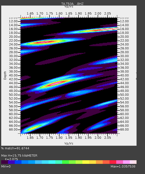
T53A Wise, VA, USA - Earthquake Result Viewer
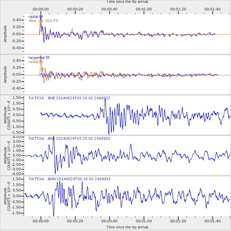
Earthquake location: Rat Islands, Aleutian Islands
Earthquake latitude/longitude: 52.3/176.7
Earthquake time(UTC): 2014/06/24 (175) 03:15:36 GMT
Earthquake Depth: 4.0 km
Earthquake Magnitude: 6.3 MWB, 5.7 ML, 6.4 MWC, 6.6 MI
Earthquake Catalog/Contributor: NEIC PDE/NEIC COMCAT
Network: TA USArray Transportable Network (new EarthScope stations)
Station: T53A Wise, VA, USA
Lat/Lon: 36.98 N/82.54 W
Elevation: 818 m
Distance: 67.6 deg
Az: 58.292 deg
Baz: 319.222 deg
Ray Param: 0.056844924
Estimated Moho Depth: 15.75 km
Estimated Crust Vp/Vs: 2.08
Assumed Crust Vp: 6.476 km/s
Estimated Crust Vs: 3.121 km/s
Estimated Crust Poisson's Ratio: 0.35
Radial Match: 91.6744 %
Radial Bump: 400
Transverse Match: 78.147285 %
Transverse Bump: 400
SOD ConfigId: 739768
Insert Time: 2014-07-08 04:22:00.837 +0000
GWidth: 2.5
Max Bumps: 400
Tol: 0.001

Signal To Noise

ChannelStoNSTALTA
TA:T53A: :BHZ:20140624T03:26:03.249993Z5.82834158.11141E-71.3917183E-7
TA:T53A: :BHN:20140624T03:26:03.249993Z1.94061972.3948874E-71.2340838E-7
TA:T53A: :BHE:20140624T03:26:03.249993Z2.16197442.1119104E-79.7684335E-8
Arrivals
Ps2.7 SECOND
PpPs7.2 SECOND
PsPs/PpSs9.9 SECOND