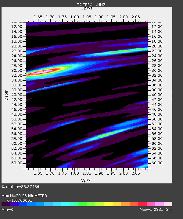
TPFO Pinon Flats, CA, USA - Earthquake Result Viewer
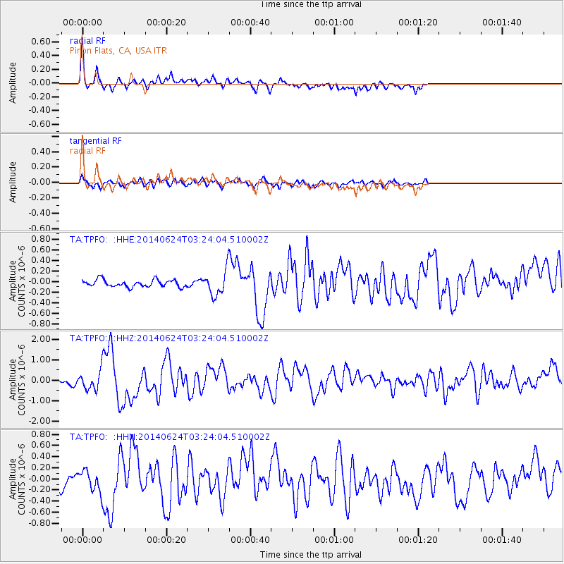
Earthquake location: Rat Islands, Aleutian Islands
Earthquake latitude/longitude: 52.3/176.7
Earthquake time(UTC): 2014/06/24 (175) 03:15:36 GMT
Earthquake Depth: 4.0 km
Earthquake Magnitude: 6.3 MWB, 5.7 ML, 6.4 MWC, 6.6 MI
Earthquake Catalog/Contributor: NEIC PDE/NEIC COMCAT
Network: TA USArray Transportable Network (new EarthScope stations)
Station: TPFO Pinon Flats, CA, USA
Lat/Lon: 33.61 N/116.45 W
Elevation: 1275 m
Distance: 50.5 deg
Az: 84.071 deg
Baz: 312.889 deg
Ray Param: 0.06804626
Estimated Moho Depth: 30.25 km
Estimated Crust Vp/Vs: 1.67
Assumed Crust Vp: 6.264 km/s
Estimated Crust Vs: 3.751 km/s
Estimated Crust Poisson's Ratio: 0.22
Radial Match: 83.37436 %
Radial Bump: 349
Transverse Match: 69.885704 %
Transverse Bump: 400
SOD ConfigId: 739768
Insert Time: 2014-07-08 04:22:19.976 +0000
GWidth: 2.5
Max Bumps: 400
Tol: 0.001

Signal To Noise

ChannelStoNSTALTA
TA:TPFO: :HHZ:20140624T03:24:04.510002Z2.99712594.911069E-71.6385928E-7
TA:TPFO: :HHN:20140624T03:24:04.510002Z1.94419441.9756119E-71.0161597E-7
TA:TPFO: :HHE:20140624T03:24:04.510002Z3.64177272.426303E-76.662423E-8
Arrivals
Ps3.4 SECOND
PpPs12 SECOND
PsPs/PpSs16 SECOND