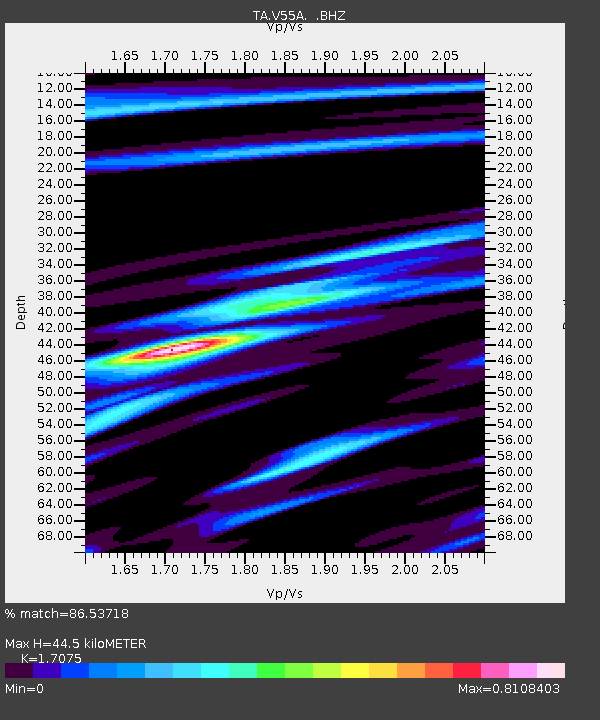
V55A Taylorsville, NC, USA - Earthquake Result Viewer
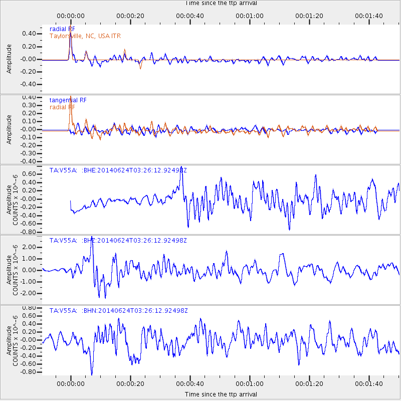
Earthquake location: Rat Islands, Aleutian Islands
Earthquake latitude/longitude: 52.3/176.7
Earthquake time(UTC): 2014/06/24 (175) 03:15:36 GMT
Earthquake Depth: 4.0 km
Earthquake Magnitude: 6.3 MWB, 5.7 ML, 6.4 MWC, 6.6 MI
Earthquake Catalog/Contributor: NEIC PDE/NEIC COMCAT
Network: TA USArray Transportable Network (new EarthScope stations)
Station: V55A Taylorsville, NC, USA
Lat/Lon: 35.85 N/81.21 W
Elevation: 306 m
Distance: 69.2 deg
Az: 58.207 deg
Baz: 319.971 deg
Ray Param: 0.055832297
Estimated Moho Depth: 44.5 km
Estimated Crust Vp/Vs: 1.71
Assumed Crust Vp: 6.419 km/s
Estimated Crust Vs: 3.759 km/s
Estimated Crust Poisson's Ratio: 0.24
Radial Match: 86.53718 %
Radial Bump: 400
Transverse Match: 67.73863 %
Transverse Bump: 400
SOD ConfigId: 739768
Insert Time: 2014-07-08 04:22:50.268 +0000
GWidth: 2.5
Max Bumps: 400
Tol: 0.001

Signal To Noise

ChannelStoNSTALTA
TA:V55A: :BHZ:20140624T03:26:12.92498Z3.62662985.5024026E-71.517222E-7
TA:V55A: :BHN:20140624T03:26:12.92498Z1.4674521.4171584E-79.657272E-8
TA:V55A: :BHE:20140624T03:26:12.92498Z1.40997741.4489093E-71.0276116E-7
Arrivals
Ps5.1 SECOND
PpPs18 SECOND
PsPs/PpSs23 SECOND