You are here: Home > Network List > TA - USArray Transportable Network (new EarthScope stations) Stations List
> Station W54A Cherokee Point, Campobello, SC, USA > Earthquake Result Viewer
W54A Cherokee Point, Campobello, SC, USA - Earthquake Result Viewer

| Earthquake location: |
Rat Islands, Aleutian Islands |
| Earthquake latitude/longitude: |
52.3/176.7 |
| Earthquake time(UTC): |
2014/06/24 (175) 03:15:36 GMT |
| Earthquake Depth: |
4.0 km |
| Earthquake Magnitude: |
6.3 MWB, 5.7 ML, 6.4 MWC, 6.6 MI |
| Earthquake Catalog/Contributor: |
NEIC PDE/NEIC COMCAT |
|
| Network: |
TA USArray Transportable Network (new EarthScope stations) |
| Station: |
W54A Cherokee Point, Campobello, SC, USA |
| Lat/Lon: |
35.09 N/82.19 W |
| Elevation: |
272 m |
|
| Distance: |
69.3 deg |
| Az: |
59.382 deg |
| Baz: |
319.827 deg |
| Ray Param: |
0.055783484 |
| Estimated Moho Depth: |
16.25 km |
| Estimated Crust Vp/Vs: |
2.10 |
| Assumed Crust Vp: |
6.35 km/s |
| Estimated Crust Vs: |
3.027 km/s |
| Estimated Crust Poisson's Ratio: |
0.35 |
|
| Radial Match: |
88.541725 % |
| Radial Bump: |
384 |
| Transverse Match: |
55.52463 % |
| Transverse Bump: |
400 |
| SOD ConfigId: |
739768 |
| Insert Time: |
2014-07-08 04:23:21.552 +0000 |
| GWidth: |
2.5 |
| Max Bumps: |
400 |
| Tol: |
0.001 |
|
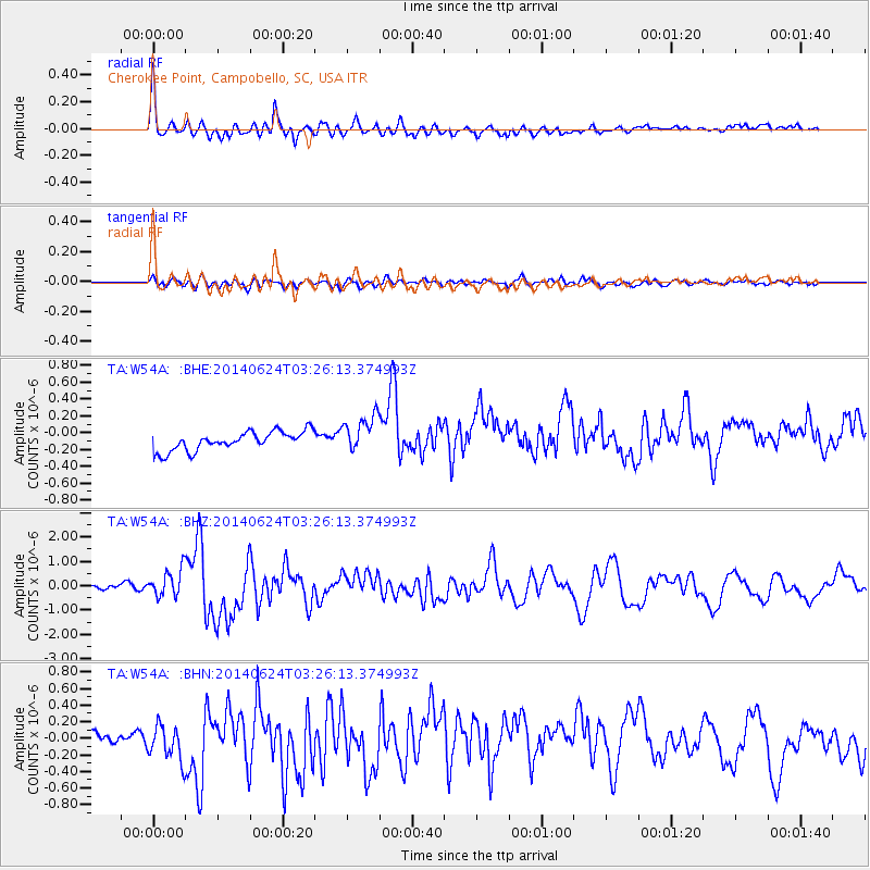
Signal To Noise
| Channel | StoN | STA | LTA |
| TA:W54A: :BHZ:20140624T03:26:13.374993Z | 5.0820603 | 6.0046364E-7 | 1.1815358E-7 |
| TA:W54A: :BHN:20140624T03:26:13.374993Z | 2.3991265 | 2.2908588E-7 | 9.54872E-8 |
| TA:W54A: :BHE:20140624T03:26:13.374993Z | 1.9808664 | 2.2263171E-7 | 1.1239107E-7 |
| Arrivals |
| Ps | 2.9 SECOND |
| PpPs | 7.7 SECOND |
| PsPs/PpSs | 11 SECOND |


