You are here: Home > Network List > II - Global Seismograph Network (GSN - IRIS/IDA) Stations List
> Station WRAB Tennant Creek, NT, Australia > Earthquake Result Viewer
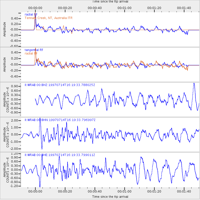
WRAB Tennant Creek, NT, Australia - Earthquake Result Viewer
*The percent match for this event was below the threshold and hence no stack was calculated.
| Earthquake location: |
Kuril Islands |
| Earthquake latitude/longitude: |
43.2/146.4 |
| Earthquake time(UTC): |
1997/07/14 (195) 16:09:35 GMT |
| Earthquake Depth: |
33 km |
| Earthquake Magnitude: |
5.9 MB, 5.8 MS, 6.1 UNKNOWN, 5.8 ME |
| Earthquake Catalog/Contributor: |
WHDF/NEIC |
|
| Network: |
II Global Seismograph Network (GSN - IRIS/IDA) |
| Station: |
WRAB Tennant Creek, NT, Australia |
| Lat/Lon: |
19.93 S/134.36 E |
| Elevation: |
366 m |
|
| Distance: |
63.8 deg |
| Az: |
192.61 deg |
| Baz: |
9.762 deg |
| Ray Param: |
$rayparam |
*The percent match for this event was below the threshold and hence was not used in the summary stack. |
|
| Radial Match: |
68.3527 % |
| Radial Bump: |
400 |
| Transverse Match: |
54.575836 % |
| Transverse Bump: |
390 |
| SOD ConfigId: |
4480 |
| Insert Time: |
2010-03-01 23:32:17.583 +0000 |
| GWidth: |
2.5 |
| Max Bumps: |
400 |
| Tol: |
0.001 |
|
Signal To Noise
| Channel | StoN | STA | LTA |
| II:WRAB:00:BHN:19970714T16:19:33.796997Z | 2.3561928 | 1.0153117E-6 | 4.3091194E-7 |
| II:WRAB:00:BHE:19970714T16:19:33.799011Z | 2.9679966 | 6.1345133E-7 | 2.0668868E-7 |
| II:WRAB:00:BHZ:19970714T16:19:33.788025Z | 1.1574433 | 2.684436E-7 | 2.319281E-7 |
| Arrivals |
| Ps | |
| PpPs | |
| PsPs/PpSs | |


