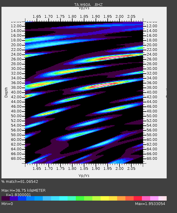
W60A Pink Hill, NC, USA - Earthquake Result Viewer

Earthquake location: Rat Islands, Aleutian Islands
Earthquake latitude/longitude: 52.3/176.7
Earthquake time(UTC): 2014/06/24 (175) 03:15:36 GMT
Earthquake Depth: 4.0 km
Earthquake Magnitude: 6.3 MWB, 5.7 ML, 6.4 MWC, 6.6 MI
Earthquake Catalog/Contributor: NEIC PDE/NEIC COMCAT
Network: TA USArray Transportable Network (new EarthScope stations)
Station: W60A Pink Hill, NC, USA
Lat/Lon: 35.05 N/77.71 W
Elevation: 30 m
Distance: 71.6 deg
Az: 56.395 deg
Baz: 321.385 deg
Ray Param: 0.05422835
Estimated Moho Depth: 36.75 km
Estimated Crust Vp/Vs: 1.93
Assumed Crust Vp: 6.565 km/s
Estimated Crust Vs: 3.401 km/s
Estimated Crust Poisson's Ratio: 0.32
Radial Match: 81.06542 %
Radial Bump: 400
Transverse Match: 78.66448 %
Transverse Bump: 400
SOD ConfigId: 739768
Insert Time: 2014-07-08 04:23:30.926 +0000
GWidth: 2.5
Max Bumps: 400
Tol: 0.001

Signal To Noise

ChannelStoNSTALTA
TA:W60A: :BHZ:20140624T03:26:27.725029Z3.1288636.1069727E-71.9518184E-7
TA:W60A: :BHN:20140624T03:26:27.725029Z0.999678972.627268E-72.6281114E-7
TA:W60A: :BHE:20140624T03:26:27.725029Z1.18518482.9242372E-72.4673258E-7
Arrivals
Ps5.4 SECOND
PpPs16 SECOND
PsPs/PpSs21 SECOND