You are here: Home > Network List > II - Global Seismograph Network (GSN - IRIS/IDA) Stations List
> Station WRAB Tennant Creek, NT, Australia > Earthquake Result Viewer
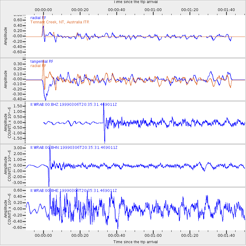
WRAB Tennant Creek, NT, Australia - Earthquake Result Viewer
*The percent match for this event was below the threshold and hence no stack was calculated.
| Earthquake location: |
Fiji Islands Region |
| Earthquake latitude/longitude: |
-21.7/-179.5 |
| Earthquake time(UTC): |
1999/03/06 (065) 20:28:53 GMT |
| Earthquake Depth: |
603 km |
| Earthquake Magnitude: |
5.4 MB, 5.8 MW, 5.7 MW |
| Earthquake Catalog/Contributor: |
WHDF/NEIC |
|
| Network: |
II Global Seismograph Network (GSN - IRIS/IDA) |
| Station: |
WRAB Tennant Creek, NT, Australia |
| Lat/Lon: |
19.93 S/134.36 E |
| Elevation: |
366 m |
|
| Distance: |
43.1 deg |
| Az: |
263.673 deg |
| Baz: |
100.817 deg |
| Ray Param: |
$rayparam |
*The percent match for this event was below the threshold and hence was not used in the summary stack. |
|
| Radial Match: |
48.60508 % |
| Radial Bump: |
400 |
| Transverse Match: |
65.16588 % |
| Transverse Bump: |
400 |
| SOD ConfigId: |
4480 |
| Insert Time: |
2010-03-01 23:32:20.082 +0000 |
| GWidth: |
2.5 |
| Max Bumps: |
400 |
| Tol: |
0.001 |
|
Signal To Noise
| Channel | StoN | STA | LTA |
| II:WRAB:00:BHN:19990306T20:35:31.469011Z | 8.738921 | 1.1275865E-6 | 1.2903041E-7 |
| II:WRAB:00:BHE:19990306T20:35:31.469011Z | 1.7201658 | 1.8911783E-7 | 1.09941624E-7 |
| II:WRAB:00:BHZ:19990306T20:35:31.469011Z | 6.3036613 | 5.9623966E-7 | 9.458624E-8 |
| Arrivals |
| Ps | |
| PpPs | |
| PsPs/PpSs | |


