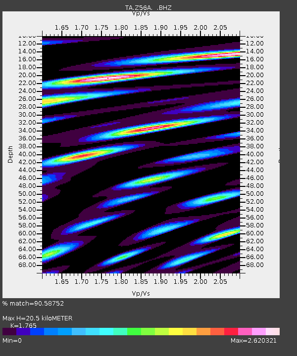
Z56A Williston, SC, USA - Earthquake Result Viewer
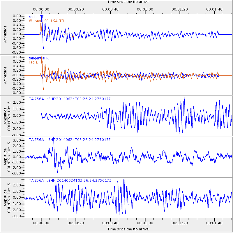
Earthquake location: Rat Islands, Aleutian Islands
Earthquake latitude/longitude: 52.3/176.7
Earthquake time(UTC): 2014/06/24 (175) 03:15:36 GMT
Earthquake Depth: 4.0 km
Earthquake Magnitude: 6.3 MWB, 5.7 ML, 6.4 MWC, 6.6 MI
Earthquake Catalog/Contributor: NEIC PDE/NEIC COMCAT
Network: TA USArray Transportable Network (new EarthScope stations)
Station: Z56A Williston, SC, USA
Lat/Lon: 33.33 N/81.37 W
Elevation: 81 m
Distance: 71.0 deg
Az: 60.025 deg
Baz: 320.503 deg
Ray Param: 0.05459997
Estimated Moho Depth: 20.5 km
Estimated Crust Vp/Vs: 1.76
Assumed Crust Vp: 6.565 km/s
Estimated Crust Vs: 3.719 km/s
Estimated Crust Poisson's Ratio: 0.26
Radial Match: 90.58752 %
Radial Bump: 400
Transverse Match: 79.77107 %
Transverse Bump: 400
SOD ConfigId: 739768
Insert Time: 2014-07-08 04:24:16.236 +0000
GWidth: 2.5
Max Bumps: 400
Tol: 0.001

Signal To Noise

ChannelStoNSTALTA
TA:Z56A: :BHZ:20140624T03:26:24.275017Z5.23300656.4595514E-71.2343862E-7
TA:Z56A: :BHN:20140624T03:26:24.275017Z2.46377924.7080633E-71.9109112E-7
TA:Z56A: :BHE:20140624T03:26:24.275017Z1.80454354.2915795E-72.3782079E-7
Arrivals
Ps2.5 SECOND
PpPs8.3 SECOND
PsPs/PpSs11 SECOND