You are here: Home > Network List > II - Global Seismograph Network (GSN - IRIS/IDA) Stations List
> Station WRAB Tennant Creek, NT, Australia > Earthquake Result Viewer
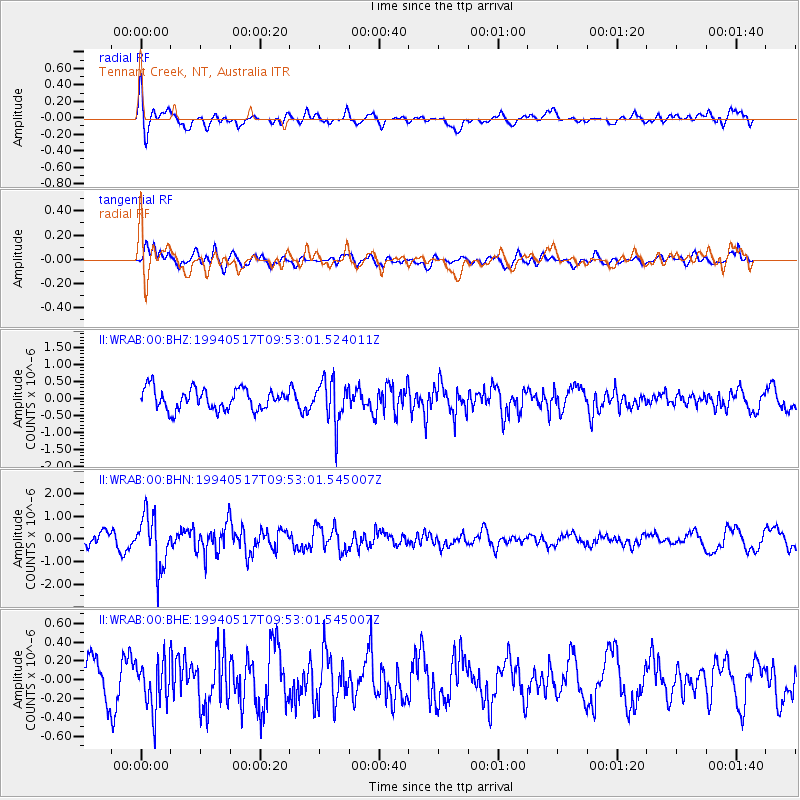
WRAB Tennant Creek, NT, Australia - Earthquake Result Viewer
*The percent match for this event was below the threshold and hence no stack was calculated.
| Earthquake location: |
Southern Sumatra, Indonesia |
| Earthquake latitude/longitude: |
-1.9/99.5 |
| Earthquake time(UTC): |
1994/05/17 (137) 09:46:13 GMT |
| Earthquake Depth: |
33 km |
| Earthquake Magnitude: |
5.7 MB, 5.6 MS |
| Earthquake Catalog/Contributor: |
WHDF/NEIC |
|
| Network: |
II Global Seismograph Network (GSN - IRIS/IDA) |
| Station: |
WRAB Tennant Creek, NT, Australia |
| Lat/Lon: |
19.93 S/134.36 E |
| Elevation: |
366 m |
|
| Distance: |
38.5 deg |
| Az: |
120.298 deg |
| Baz: |
293.472 deg |
| Ray Param: |
$rayparam |
*The percent match for this event was below the threshold and hence was not used in the summary stack. |
|
| Radial Match: |
62.28166 % |
| Radial Bump: |
400 |
| Transverse Match: |
80.60511 % |
| Transverse Bump: |
400 |
| SOD ConfigId: |
4480 |
| Insert Time: |
2010-03-01 23:32:22.313 +0000 |
| GWidth: |
2.5 |
| Max Bumps: |
400 |
| Tol: |
0.001 |
|
Signal To Noise
| Channel | StoN | STA | LTA |
| II:WRAB:00:BHN:19940517T09:53:01.545007Z | 3.7888377 | 1.1580483E-6 | 3.0564738E-7 |
| II:WRAB:00:BHE:19940517T09:53:01.545007Z | 1.4080857 | 2.6407238E-7 | 1.8754E-7 |
| II:WRAB:00:BHZ:19940517T09:53:01.524011Z | 2.0782573 | 6.3634224E-7 | 3.0619032E-7 |
| Arrivals |
| Ps | |
| PpPs | |
| PsPs/PpSs | |


