PMG Port Moresby, New Guinea - Earthquake Result Viewer
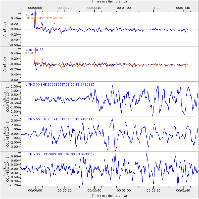
Earthquake location: Southern Sumatra, Indonesia
Earthquake latitude/longitude: -2.5/101.5
Earthquake time(UTC): 2009/10/01 (274) 01:52:27 GMT
Earthquake Depth: 9.7 km
Earthquake Magnitude: 5.9 MB, 6.7 MS, 6.6 MW, 6.6 MW
Earthquake Catalog/Contributor: WHDF/NEIC
Network: IU Global Seismograph Network (GSN - IRIS/USGS)
Station: PMG Port Moresby, New Guinea
Lat/Lon: 9.40 S/147.16 E
Elevation: 90 m
Distance: 45.9 deg
Az: 100.605 deg
Baz: 275.623 deg
Ray Param: 0.07098666
Estimated Moho Depth: 31.5 km
Estimated Crust Vp/Vs: 1.95
Assumed Crust Vp: 6.122 km/s
Estimated Crust Vs: 3.139 km/s
Estimated Crust Poisson's Ratio: 0.32
Radial Match: 93.82178 %
Radial Bump: 400
Transverse Match: 84.358345 %
Transverse Bump: 400
SOD ConfigId: 1
Insert Time: 2010-02-19 00:27:00.082 +0000
GWidth: 2.5
Max Bumps: 400
Tol: 0.001

Signal To Noise

ChannelStoNSTALTA
IU:PMG:00:BHZ:20091001T02:00:18.948011Z2.9040475.049228E-71.7386867E-7
IU:PMG:00:BHN:20091001T02:00:18.948011Z1.23932211.564232E-71.2621675E-7
IU:PMG:00:BHE:20091001T02:00:18.948011Z0.84706971.3469877E-71.5901733E-7
Arrivals
Ps5.1 SECOND
PpPs14 SECOND
PsPs/PpSs20 SECOND