You are here: Home > Network List > II - Global Seismograph Network (GSN - IRIS/IDA) Stations List
> Station WRAB Tennant Creek, NT, Australia > Earthquake Result Viewer
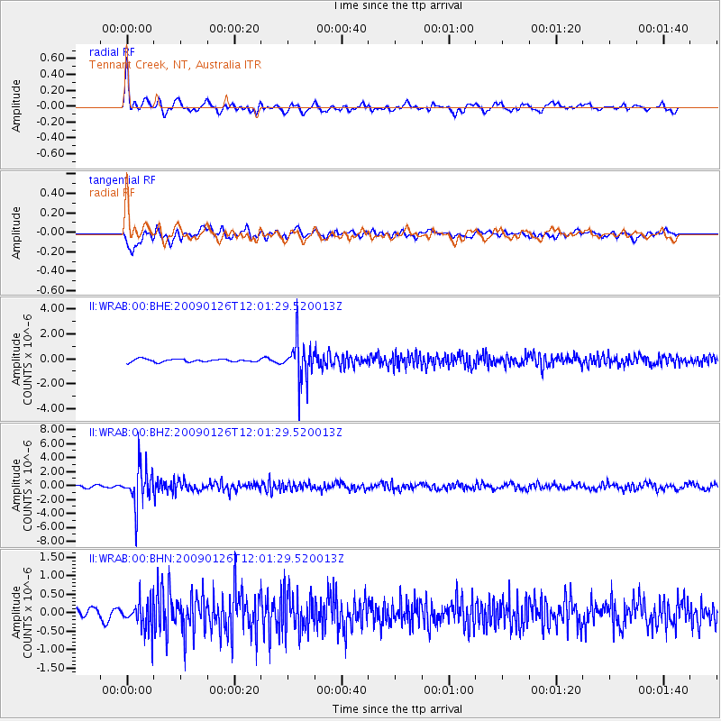
WRAB Tennant Creek, NT, Australia - Earthquake Result Viewer
*The percent match for this event was below the threshold and hence no stack was calculated.
| Earthquake location: |
Fiji Islands Region |
| Earthquake latitude/longitude: |
-17.8/-178.6 |
| Earthquake time(UTC): |
2009/01/26 (026) 11:54:39 GMT |
| Earthquake Depth: |
580 km |
| Earthquake Magnitude: |
5.5 MB, 5.8 MW, 5.8 MW |
| Earthquake Catalog/Contributor: |
WHDF/NEIC |
|
| Network: |
II Global Seismograph Network (GSN - IRIS/IDA) |
| Station: |
WRAB Tennant Creek, NT, Australia |
| Lat/Lon: |
19.93 S/134.36 E |
| Elevation: |
366 m |
|
| Distance: |
44.5 deg |
| Az: |
259.457 deg |
| Baz: |
95.389 deg |
| Ray Param: |
$rayparam |
*The percent match for this event was below the threshold and hence was not used in the summary stack. |
|
| Radial Match: |
70.87145 % |
| Radial Bump: |
376 |
| Transverse Match: |
67.8158 % |
| Transverse Bump: |
400 |
| SOD ConfigId: |
2658 |
| Insert Time: |
2010-03-01 23:32:24.392 +0000 |
| GWidth: |
2.5 |
| Max Bumps: |
400 |
| Tol: |
0.001 |
|
Signal To Noise
| Channel | StoN | STA | LTA |
| II:WRAB:00:BHZ:20090126T12:01:29.520013Z | 11.585867 | 2.768579E-6 | 2.3896175E-7 |
| II:WRAB:00:BHN:20090126T12:01:29.520013Z | 2.973041 | 4.0268634E-7 | 1.3544594E-7 |
| II:WRAB:00:BHE:20090126T12:01:29.520013Z | 13.532418 | 1.5776865E-6 | 1.16585696E-7 |
| Arrivals |
| Ps | |
| PpPs | |
| PsPs/PpSs | |


