You are here: Home > Network List > CI - Caltech Regional Seismic Network Stations List
> Station MPP McPhearson Peak > Earthquake Result Viewer
MPP McPhearson Peak - Earthquake Result Viewer
| Earthquake location: |
Northern Chile |
| Earthquake latitude/longitude: |
-18.4/-69.4 |
| Earthquake time(UTC): |
2015/03/23 (082) 04:51:37 GMT |
| Earthquake Depth: |
128 km |
| Earthquake Magnitude: |
6.1 MWP, 6.1 MO |
| Earthquake Catalog/Contributor: |
NEIC PDE/NEIC ALERT |
|
| Network: |
CI Caltech Regional Seismic Network |
| Station: |
MPP McPhearson Peak |
| Lat/Lon: |
34.89 N/119.81 W |
| Elevation: |
1739 m |
|
| Distance: |
71.5 deg |
| Az: |
318.044 deg |
| Baz: |
129.463 deg |
| Ray Param: |
0.053979773 |
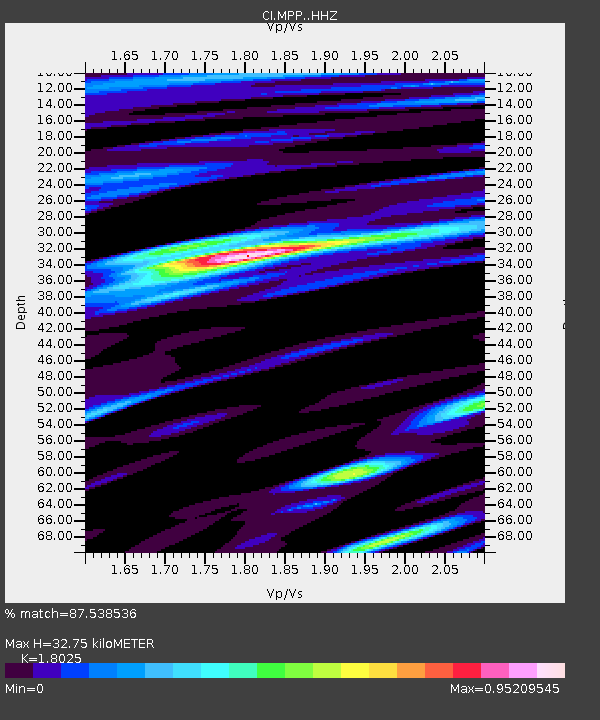
| Estimated Moho Depth: |
32.75 km |
| Estimated Crust Vp/Vs: |
1.80 |
| Assumed Crust Vp: |
6.1 km/s |
| Estimated Crust Vs: |
3.384 km/s |
| Estimated Crust Poisson's Ratio: |
0.28 |
|
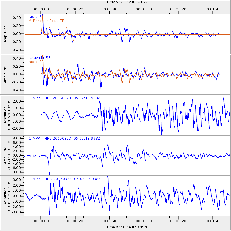
| Radial Match: |
87.538536 % |
| Radial Bump: |
400 |
| Transverse Match: |
81.16093 % |
| Transverse Bump: |
400 |
| SOD ConfigId: |
7422571 |
| Insert Time: |
2019-04-17 21:19:43.364 +0000 |
| GWidth: |
2.5 |
| Max Bumps: |
400 |
| Tol: |
0.001 |
|
Signal To Noise
| Channel | StoN | STA | LTA |
| CI:MPP: :HHZ:20150323T05:02:13.938Z | 9.675348 | 2.0527045E-6 | 2.121582E-7 |
| CI:MPP: :HHN:20150323T05:02:13.938Z | 1.7859583 | 4.7182556E-7 | 2.641862E-7 |
| CI:MPP: :HHE:20150323T05:02:13.938Z | 1.0138186 | 4.55506E-7 | 4.4929732E-7 |
| Arrivals |
| Ps | 4.4 SECOND |
| PpPs | 15 SECOND |
| PsPs/PpSs | 19 SECOND |


