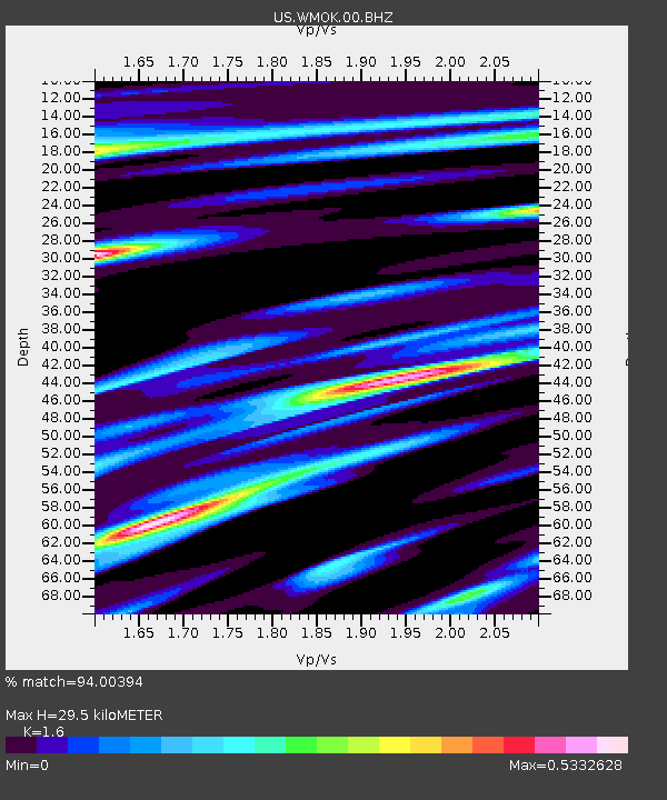
WMOK Wichita Mountains, Oklahoma, USA - Earthquake Result Viewer

Earthquake location: Rat Islands, Aleutian Islands
Earthquake latitude/longitude: 52.3/176.7
Earthquake time(UTC): 2014/06/24 (175) 03:15:36 GMT
Earthquake Depth: 4.0 km
Earthquake Magnitude: 6.3 MWB, 5.7 ML, 6.4 MWC, 6.6 MI
Earthquake Catalog/Contributor: NEIC PDE/NEIC COMCAT
Network: US United States National Seismic Network
Station: WMOK Wichita Mountains, Oklahoma, USA
Lat/Lon: 34.74 N/98.78 W
Elevation: 486 m
Distance: 60.3 deg
Az: 70.736 deg
Baz: 315.197 deg
Ray Param: 0.061656095
Estimated Moho Depth: 29.5 km
Estimated Crust Vp/Vs: 1.60
Assumed Crust Vp: 6.315 km/s
Estimated Crust Vs: 3.947 km/s
Estimated Crust Poisson's Ratio: 0.18
Radial Match: 94.00394 %
Radial Bump: 400
Transverse Match: 87.05247 %
Transverse Bump: 400
SOD ConfigId: 739768
Insert Time: 2014-07-08 04:28:37.595 +0000
GWidth: 2.5
Max Bumps: 400
Tol: 0.001

Signal To Noise

ChannelStoNSTALTA
US:WMOK:00:BHZ:20140624T03:25:14.950005Z5.15274525.627427E-71.092122E-7
US:WMOK:00:BH1:20140624T03:25:14.950005Z5.23597341.4832976E-72.8328975E-8
US:WMOK:00:BH2:20140624T03:25:14.950005Z3.06281761.68183E-75.4911208E-8
Arrivals
Ps2.9 SECOND
PpPs12 SECOND
PsPs/PpSs14 SECOND