You are here: Home > Network List > II - Global Seismograph Network (GSN - IRIS/IDA) Stations List
> Station WRAB Tennant Creek, NT, Australia > Earthquake Result Viewer
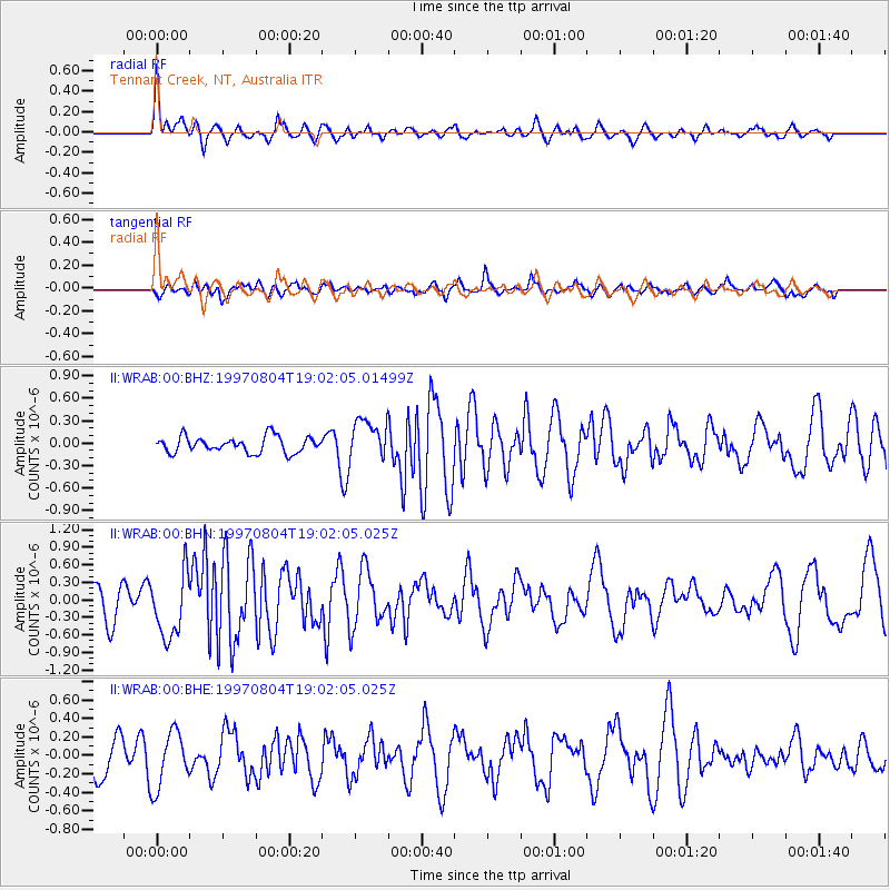
WRAB Tennant Creek, NT, Australia - Earthquake Result Viewer
*The percent match for this event was below the threshold and hence no stack was calculated.
| Earthquake location: |
Tonga Islands |
| Earthquake latitude/longitude: |
-15.2/-175.3 |
| Earthquake time(UTC): |
1997/08/04 (216) 18:53:58 GMT |
| Earthquake Depth: |
33 km |
| Earthquake Magnitude: |
5.5 MB, 6.0 MS, 6.1 UNKNOWN, 6.0 MW |
| Earthquake Catalog/Contributor: |
WHDF/NEIC |
|
| Network: |
II Global Seismograph Network (GSN - IRIS/IDA) |
| Station: |
WRAB Tennant Creek, NT, Australia |
| Lat/Lon: |
19.93 S/134.36 E |
| Elevation: |
366 m |
|
| Distance: |
48.1 deg |
| Az: |
256.698 deg |
| Baz: |
92.752 deg |
| Ray Param: |
$rayparam |
*The percent match for this event was below the threshold and hence was not used in the summary stack. |
|
| Radial Match: |
70.340866 % |
| Radial Bump: |
400 |
| Transverse Match: |
57.965782 % |
| Transverse Bump: |
400 |
| SOD ConfigId: |
4480 |
| Insert Time: |
2010-03-01 23:32:24.973 +0000 |
| GWidth: |
2.5 |
| Max Bumps: |
400 |
| Tol: |
0.001 |
|
Signal To Noise
| Channel | StoN | STA | LTA |
| II:WRAB:00:BHN:19970804T19:02:05.025Z | 1.9558772 | 5.533378E-7 | 2.829103E-7 |
| II:WRAB:00:BHE:19970804T19:02:05.025Z | 1.5426409 | 3.0071962E-7 | 1.9493818E-7 |
| II:WRAB:00:BHZ:19970804T19:02:05.01499Z | 2.5096512 | 2.6679766E-7 | 1.0630866E-7 |
| Arrivals |
| Ps | |
| PpPs | |
| PsPs/PpSs | |


