LON Longmire (broad-band and DWWSSN) - Earthquake Result Viewer
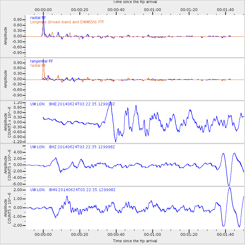
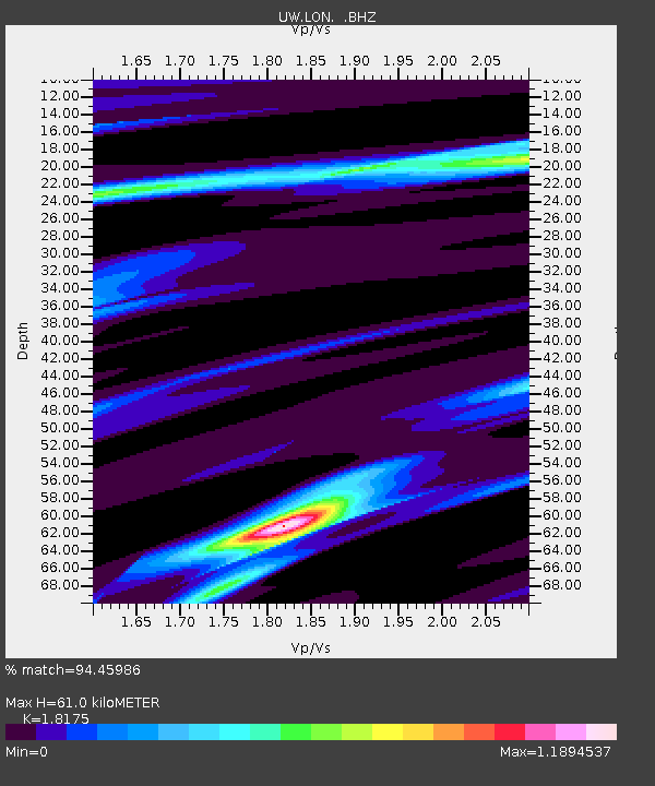
Earthquake location: Rat Islands, Aleutian Islands
Earthquake latitude/longitude: 52.3/176.7
Earthquake time(UTC): 2014/06/24 (175) 03:15:36 GMT
Earthquake Depth: 4.0 km
Earthquake Magnitude: 6.3 MWB, 5.7 ML, 6.4 MWC, 6.6 MI
Earthquake Catalog/Contributor: NEIC PDE/NEIC COMCAT
Network: UW Pacific Northwest Regional Seismic Network
Station: LON Longmire (broad-band and DWWSSN)
Lat/Lon: 46.75 N/121.81 W
Elevation: 850 m
Distance: 39.2 deg
Az: 72.77 deg
Baz: 301.36 deg
Ray Param: 0.07511538
Estimated Moho Depth: 61.0 km
Estimated Crust Vp/Vs: 1.82
Assumed Crust Vp: 6.597 km/s
Estimated Crust Vs: 3.63 km/s
Estimated Crust Poisson's Ratio: 0.28
Radial Match: 94.45986 %
Radial Bump: 215
Transverse Match: 75.2279 %
Transverse Bump: 400
SOD ConfigId: 739768
Insert Time: 2014-07-08 04:31:31.634 +0000
GWidth: 2.5
Max Bumps: 400
Tol: 0.001

Signal To Noise

ChannelStoNSTALTA
UW:LON: :BHZ:20140624T03:22:35.129998Z2.6030674.0069898E-71.5393341E-7
UW:LON: :BHN:20140624T03:22:35.129998Z1.97718727.736761E-83.913014E-8
UW:LON: :BHE:20140624T03:22:35.129998Z1.94194782.0766106E-71.0693442E-7
Arrivals
Ps8.1 SECOND
PpPs24 SECOND
PsPs/PpSs32 SECOND