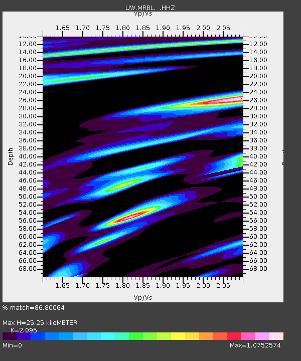
MRBL Marblemount, WA, USA - Earthquake Result Viewer
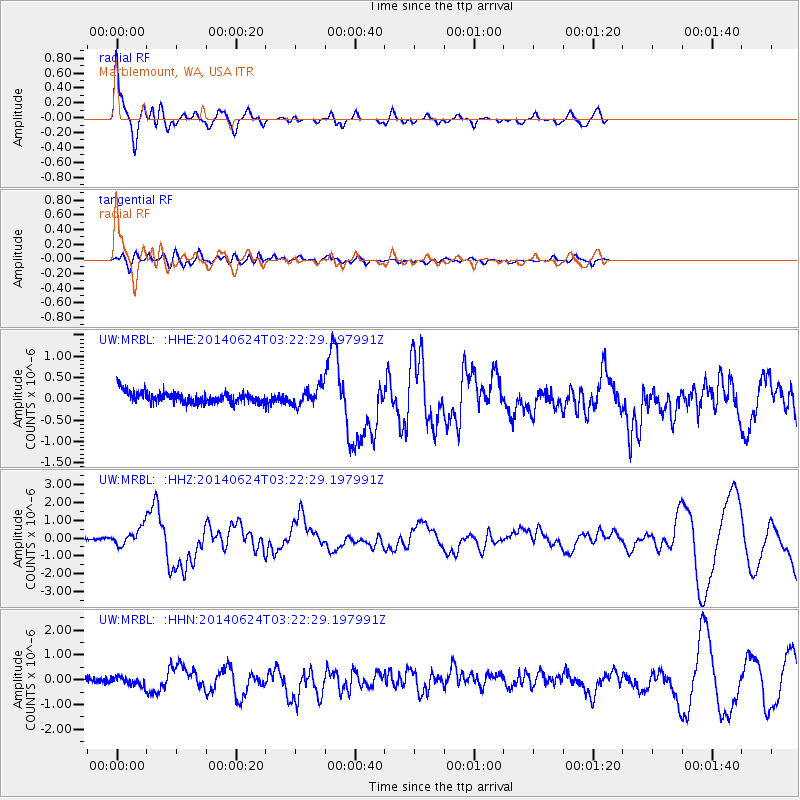
Earthquake location: Rat Islands, Aleutian Islands
Earthquake latitude/longitude: 52.3/176.7
Earthquake time(UTC): 2014/06/24 (175) 03:15:36 GMT
Earthquake Depth: 4.0 km
Earthquake Magnitude: 6.3 MWB, 5.7 ML, 6.4 MWC, 6.6 MI
Earthquake Catalog/Contributor: NEIC PDE/NEIC COMCAT
Network: UW Pacific Northwest Regional Seismic Network
Station: MRBL Marblemount, WA, USA
Lat/Lon: 48.52 N/121.48 W
Elevation: 75 m
Distance: 38.5 deg
Az: 70.163 deg
Baz: 299.57 deg
Ray Param: 0.075524144
Estimated Moho Depth: 25.25 km
Estimated Crust Vp/Vs: 2.10
Assumed Crust Vp: 6.566 km/s
Estimated Crust Vs: 3.134 km/s
Estimated Crust Poisson's Ratio: 0.35
Radial Match: 86.80064 %
Radial Bump: 344
Transverse Match: 67.302826 %
Transverse Bump: 400
SOD ConfigId: 739768
Insert Time: 2014-07-08 04:31:42.243 +0000
GWidth: 2.5
Max Bumps: 400
Tol: 0.001

Signal To Noise

ChannelStoNSTALTA
UW:MRBL: :HHZ:20140624T03:22:29.197991Z2.78328595.5526914E-71.995013E-7
UW:MRBL: :HHN:20140624T03:22:29.197991Z1.65293171.7082468E-71.0334648E-7
UW:MRBL: :HHE:20140624T03:22:29.197991Z1.56283572.0421463E-71.3066929E-7
Arrivals
Ps4.5 SECOND
PpPs11 SECOND
PsPs/PpSs16 SECOND