You are here: Home > Network List > II - Global Seismograph Network (GSN - IRIS/IDA) Stations List
> Station WRAB Tennant Creek, NT, Australia > Earthquake Result Viewer
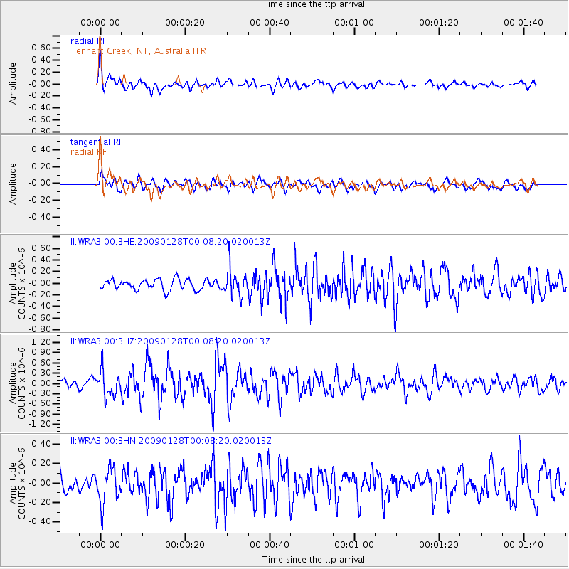
WRAB Tennant Creek, NT, Australia - Earthquake Result Viewer
*The percent match for this event was below the threshold and hence no stack was calculated.
| Earthquake location: |
Southern Sumatra, Indonesia |
| Earthquake latitude/longitude: |
-0.3/98.3 |
| Earthquake time(UTC): |
2009/01/28 (028) 00:01:13 GMT |
| Earthquake Depth: |
14 km |
| Earthquake Magnitude: |
5.7 MB, 5.6 MS, 5.7 MW, 5.7 MW |
| Earthquake Catalog/Contributor: |
WHDF/NEIC |
|
| Network: |
II Global Seismograph Network (GSN - IRIS/IDA) |
| Station: |
WRAB Tennant Creek, NT, Australia |
| Lat/Lon: |
19.93 S/134.36 E |
| Elevation: |
366 m |
|
| Distance: |
40.4 deg |
| Az: |
121.186 deg |
| Baz: |
294.592 deg |
| Ray Param: |
$rayparam |
*The percent match for this event was below the threshold and hence was not used in the summary stack. |
|
| Radial Match: |
68.67215 % |
| Radial Bump: |
400 |
| Transverse Match: |
62.267677 % |
| Transverse Bump: |
400 |
| SOD ConfigId: |
2658 |
| Insert Time: |
2010-03-01 23:32:31.067 +0000 |
| GWidth: |
2.5 |
| Max Bumps: |
400 |
| Tol: |
0.001 |
|
Signal To Noise
| Channel | StoN | STA | LTA |
| II:WRAB:00:BHZ:20090128T00:08:20.020013Z | 2.7038257 | 3.8147311E-7 | 1.4108643E-7 |
| II:WRAB:00:BHN:20090128T00:08:20.020013Z | 1.6728393 | 1.8417771E-7 | 1.1009886E-7 |
| II:WRAB:00:BHE:20090128T00:08:20.020013Z | 2.6771922 | 2.413078E-7 | 9.0134655E-8 |
| Arrivals |
| Ps | |
| PpPs | |
| PsPs/PpSs | |


