You are here: Home > Network List > II - Global Seismograph Network (GSN - IRIS/IDA) Stations List
> Station WRAB Tennant Creek, NT, Australia > Earthquake Result Viewer
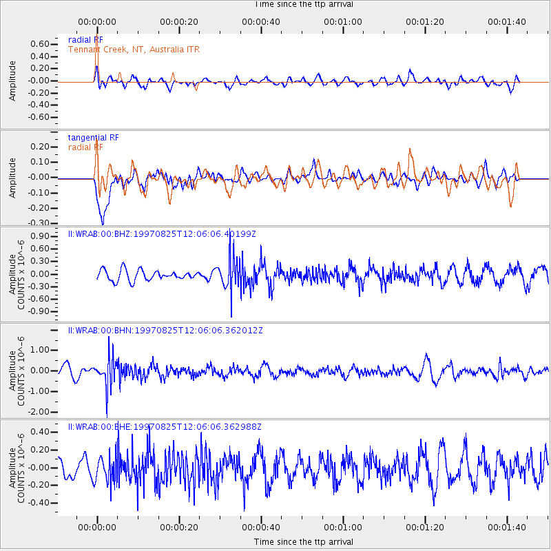
WRAB Tennant Creek, NT, Australia - Earthquake Result Viewer
*The percent match for this event was below the threshold and hence no stack was calculated.
| Earthquake location: |
Fiji Islands Region |
| Earthquake latitude/longitude: |
-20.8/-177.8 |
| Earthquake time(UTC): |
1997/08/25 (237) 11:59:00 GMT |
| Earthquake Depth: |
394 km |
| Earthquake Magnitude: |
5.5 UNKNOWN, 5.3 MB |
| Earthquake Catalog/Contributor: |
WHDF/NEIC |
|
| Network: |
II Global Seismograph Network (GSN - IRIS/IDA) |
| Station: |
WRAB Tennant Creek, NT, Australia |
| Lat/Lon: |
19.93 S/134.36 E |
| Elevation: |
366 m |
|
| Distance: |
44.7 deg |
| Az: |
262.31 deg |
| Baz: |
99.769 deg |
| Ray Param: |
$rayparam |
*The percent match for this event was below the threshold and hence was not used in the summary stack. |
|
| Radial Match: |
66.64073 % |
| Radial Bump: |
400 |
| Transverse Match: |
57.608738 % |
| Transverse Bump: |
400 |
| SOD ConfigId: |
4480 |
| Insert Time: |
2010-03-01 23:32:33.626 +0000 |
| GWidth: |
2.5 |
| Max Bumps: |
400 |
| Tol: |
0.001 |
|
Signal To Noise
| Channel | StoN | STA | LTA |
| II:WRAB:00:BHN:19970825T12:06:06.362012Z | 3.2485578 | 6.687645E-7 | 2.0586505E-7 |
| II:WRAB:00:BHE:19970825T12:06:06.362988Z | 1.1503494 | 1.4377767E-7 | 1.2498609E-7 |
| II:WRAB:00:BHZ:19970825T12:06:06.40199Z | 2.9541595 | 3.639049E-7 | 1.231839E-7 |
| Arrivals |
| Ps | |
| PpPs | |
| PsPs/PpSs | |


