You are here: Home > Network List > II - Global Seismograph Network (GSN - IRIS/IDA) Stations List
> Station WRAB Tennant Creek, NT, Australia > Earthquake Result Viewer
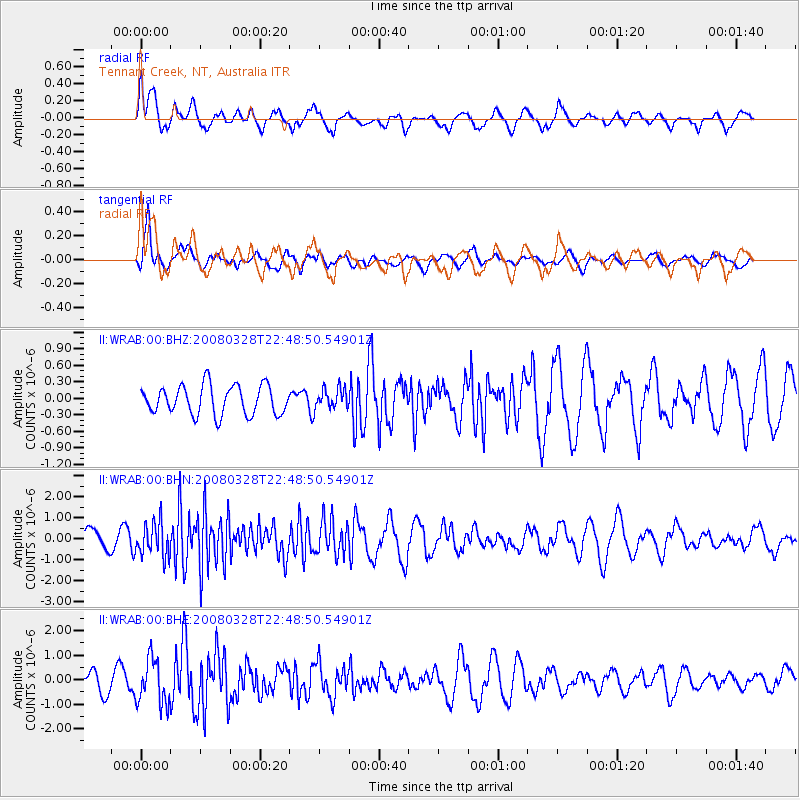
WRAB Tennant Creek, NT, Australia - Earthquake Result Viewer
*The percent match for this event was below the threshold and hence no stack was calculated.
| Earthquake location: |
Philippine Islands Region |
| Earthquake latitude/longitude: |
20.3/121.9 |
| Earthquake time(UTC): |
2008/03/28 (088) 22:41:32 GMT |
| Earthquake Depth: |
10 km |
| Earthquake Magnitude: |
5.6 MB, 5.6 MS, 5.8 MW, 5.8 MW |
| Earthquake Catalog/Contributor: |
WHDF/NEIC |
|
| Network: |
II Global Seismograph Network (GSN - IRIS/IDA) |
| Station: |
WRAB Tennant Creek, NT, Australia |
| Lat/Lon: |
19.93 S/134.36 E |
| Elevation: |
366 m |
|
| Distance: |
41.7 deg |
| Az: |
162.321 deg |
| Baz: |
342.357 deg |
| Ray Param: |
$rayparam |
*The percent match for this event was below the threshold and hence was not used in the summary stack. |
|
| Radial Match: |
61.379116 % |
| Radial Bump: |
400 |
| Transverse Match: |
87.97966 % |
| Transverse Bump: |
400 |
| SOD ConfigId: |
2504 |
| Insert Time: |
2010-03-01 23:32:36.682 +0000 |
| GWidth: |
2.5 |
| Max Bumps: |
400 |
| Tol: |
0.001 |
|
Signal To Noise
| Channel | StoN | STA | LTA |
| II:WRAB:00:BHN:20080328T22:48:50.54901Z | 1.5014364 | 8.1507983E-7 | 5.4286676E-7 |
| II:WRAB:00:BHE:20080328T22:48:50.54901Z | 2.0820596 | 9.2186235E-7 | 4.4276462E-7 |
| II:WRAB:00:BHZ:20080328T22:48:50.54901Z | 0.7067539 | 1.8629002E-7 | 2.635854E-7 |
| Arrivals |
| Ps | |
| PpPs | |
| PsPs/PpSs | |


