You are here: Home > Network List > IM - International Miscellaneous Stations Stations List
> Station NV31 NVAR Array Site 31, Mina, NV, USA > Earthquake Result Viewer
NV31 NVAR Array Site 31, Mina, NV, USA - Earthquake Result Viewer
| Earthquake location: |
Northern Chile |
| Earthquake latitude/longitude: |
-18.4/-69.4 |
| Earthquake time(UTC): |
2015/03/23 (082) 04:51:37 GMT |
| Earthquake Depth: |
128 km |
| Earthquake Magnitude: |
6.1 MWP, 6.1 MO |
| Earthquake Catalog/Contributor: |
NEIC PDE/NEIC ALERT |
|
| Network: |
IM International Miscellaneous Stations |
| Station: |
NV31 NVAR Array Site 31, Mina, NV, USA |
| Lat/Lon: |
38.43 N/118.16 W |
| Elevation: |
1509 m |
|
| Distance: |
72.7 deg |
| Az: |
321.78 deg |
| Baz: |
131.598 deg |
| Ray Param: |
0.053137407 |
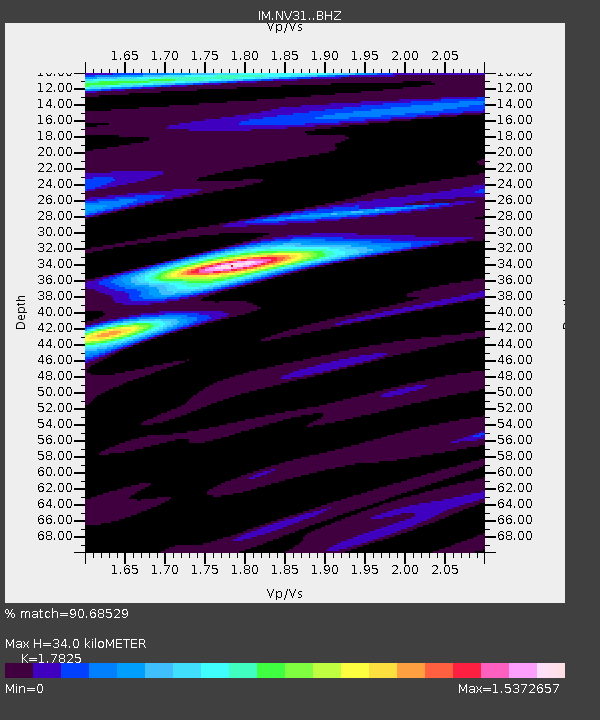
| Estimated Moho Depth: |
34.0 km |
| Estimated Crust Vp/Vs: |
1.78 |
| Assumed Crust Vp: |
6.279 km/s |
| Estimated Crust Vs: |
3.522 km/s |
| Estimated Crust Poisson's Ratio: |
0.27 |
|
| Radial Match: |
90.68529 % |
| Radial Bump: |
400 |
| Transverse Match: |
86.71944 % |
| Transverse Bump: |
400 |
| SOD ConfigId: |
7422571 |
| Insert Time: |
2019-04-17 21:21:20.297 +0000 |
| GWidth: |
2.5 |
| Max Bumps: |
400 |
| Tol: |
0.001 |
|

Signal To Noise
| Channel | StoN | STA | LTA |
| IM:NV31: :BHZ:20150323T05:02:21.500012Z | 13.272622 | 1.7646793E-6 | 1.3295634E-7 |
| IM:NV31: :BHN:20150323T05:02:21.500012Z | 3.6264951 | 3.0048133E-7 | 8.285723E-8 |
| IM:NV31: :BHE:20150323T05:02:21.500012Z | 2.7126675 | 4.0810102E-7 | 1.504427E-7 |
| Arrivals |
| Ps | 4.4 SECOND |
| PpPs | 15 SECOND |
| PsPs/PpSs | 19 SECOND |


