You are here: Home > Network List > II - Global Seismograph Network (GSN - IRIS/IDA) Stations List
> Station WRAB Tennant Creek, NT, Australia > Earthquake Result Viewer
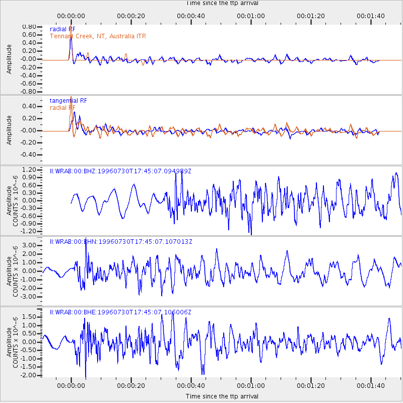
WRAB Tennant Creek, NT, Australia - Earthquake Result Viewer
*The percent match for this event was below the threshold and hence no stack was calculated.
| Earthquake location: |
Luzon, Philippines |
| Earthquake latitude/longitude: |
14.5/120.0 |
| Earthquake time(UTC): |
1996/07/30 (212) 17:38:30 GMT |
| Earthquake Depth: |
33 km |
| Earthquake Magnitude: |
6.1 MB, 5.7 MS, 6.1 UNKNOWN, 5.9 MW |
| Earthquake Catalog/Contributor: |
WHDF/NEIC |
|
| Network: |
II Global Seismograph Network (GSN - IRIS/IDA) |
| Station: |
WRAB Tennant Creek, NT, Australia |
| Lat/Lon: |
19.93 S/134.36 E |
| Elevation: |
366 m |
|
| Distance: |
37.0 deg |
| Az: |
157.136 deg |
| Baz: |
336.423 deg |
| Ray Param: |
$rayparam |
*The percent match for this event was below the threshold and hence was not used in the summary stack. |
|
| Radial Match: |
69.32559 % |
| Radial Bump: |
400 |
| Transverse Match: |
68.90637 % |
| Transverse Bump: |
400 |
| SOD ConfigId: |
4480 |
| Insert Time: |
2010-03-01 23:32:41.524 +0000 |
| GWidth: |
2.5 |
| Max Bumps: |
400 |
| Tol: |
0.001 |
|
Signal To Noise
| Channel | StoN | STA | LTA |
| II:WRAB:00:BHN:19960730T17:45:07.107013Z | 3.1490338 | 1.175772E-6 | 3.7337546E-7 |
| II:WRAB:00:BHE:19960730T17:45:07.106006Z | 3.0029855 | 6.7198124E-7 | 2.2377105E-7 |
| II:WRAB:00:BHZ:19960730T17:45:07.094989Z | 1.0590808 | 3.295583E-7 | 3.111739E-7 |
| Arrivals |
| Ps | |
| PpPs | |
| PsPs/PpSs | |


