You are here: Home > Network List > TJ - Tajikistan National Seismic Network Stations List
> Station CHGR Chuyangaron, Tajikistan > Earthquake Result Viewer
CHGR Chuyangaron, Tajikistan - Earthquake Result Viewer
| Earthquake location: |
Mindoro, Philippines |
| Earthquake latitude/longitude: |
13.6/120.7 |
| Earthquake time(UTC): |
2014/06/25 (176) 11:52:03 GMT |
| Earthquake Depth: |
77 km |
| Earthquake Magnitude: |
5.6 MB |
| Earthquake Catalog/Contributor: |
NEIC PDE/NEIC COMCAT |
|
| Network: |
TJ Tajikistan National Seismic Network |
| Station: |
CHGR Chuyangaron, Tajikistan |
| Lat/Lon: |
38.66 N/69.16 E |
| Elevation: |
1049 m |
|
| Distance: |
51.8 deg |
| Az: |
308.706 deg |
| Baz: |
104.262 deg |
| Ray Param: |
0.066960566 |
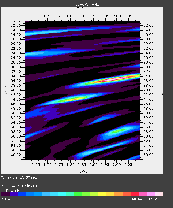
| Estimated Moho Depth: |
35.0 km |
| Estimated Crust Vp/Vs: |
1.99 |
| Assumed Crust Vp: |
6.483 km/s |
| Estimated Crust Vs: |
3.258 km/s |
| Estimated Crust Poisson's Ratio: |
0.33 |
|
| Radial Match: |
85.69995 % |
| Radial Bump: |
400 |
| Transverse Match: |
83.02215 % |
| Transverse Bump: |
400 |
| SOD ConfigId: |
751137 |
| Insert Time: |
2014-07-09 14:43:14.778 +0000 |
| GWidth: |
2.5 |
| Max Bumps: |
400 |
| Tol: |
0.001 |
|

Signal To Noise
| Channel | StoN | STA | LTA |
| TJ:CHGR: :HHZ:20140625T12:00:32.879999Z | 9.030641 | 6.544623E-7 | 7.247131E-8 |
| TJ:CHGR: :HHN:20140625T12:00:32.879999Z | 1.9059657 | 1.8991E-7 | 9.963978E-8 |
| TJ:CHGR: :HHE:20140625T12:00:32.879999Z | 3.3091426 | 3.5800426E-7 | 1.08186406E-7 |
| Arrivals |
| Ps | 5.6 SECOND |
| PpPs | 15 SECOND |
| PsPs/PpSs | 21 SECOND |


