You are here: Home > Network List > AK - Alaska Regional Network Stations List
> Station BPAW Bear Paw Mountain Broadband > Earthquake Result Viewer
BPAW Bear Paw Mountain Broadband - Earthquake Result Viewer
| Earthquake location: |
Volcano Islands, Japan Region |
| Earthquake latitude/longitude: |
24.4/142.6 |
| Earthquake time(UTC): |
2014/06/29 (180) 05:56:31 GMT |
| Earthquake Depth: |
43 km |
| Earthquake Magnitude: |
6.2 MWP |
| Earthquake Catalog/Contributor: |
NEIC PDE/NEIC COMCAT |
|
| Network: |
AK Alaska Regional Network |
| Station: |
BPAW Bear Paw Mountain Broadband |
| Lat/Lon: |
64.10 N/150.98 W |
| Elevation: |
619 m |
|
| Distance: |
58.0 deg |
| Az: |
28.32 deg |
| Baz: |
260.011 deg |
| Ray Param: |
0.06300803 |
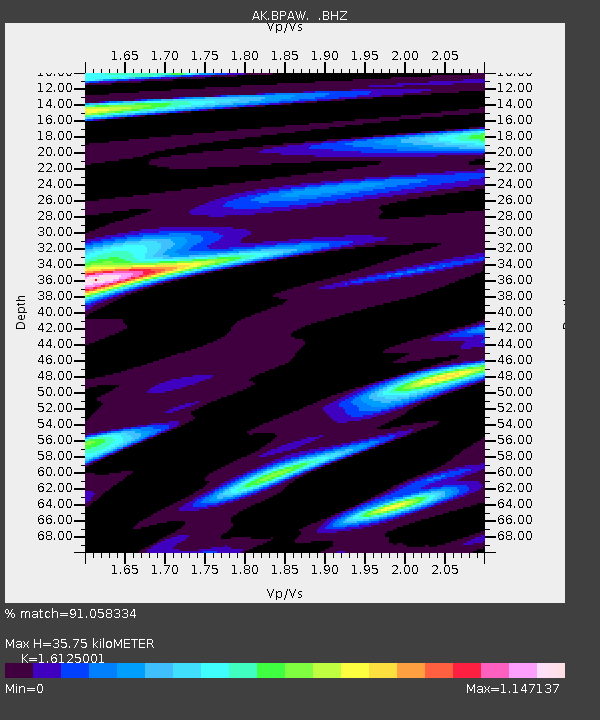
| Estimated Moho Depth: |
35.75 km |
| Estimated Crust Vp/Vs: |
1.61 |
| Assumed Crust Vp: |
6.566 km/s |
| Estimated Crust Vs: |
4.072 km/s |
| Estimated Crust Poisson's Ratio: |
0.19 |
|
| Radial Match: |
91.058334 % |
| Radial Bump: |
400 |
| Transverse Match: |
82.520706 % |
| Transverse Bump: |
400 |
| SOD ConfigId: |
751272 |
| Insert Time: |
2014-07-13 06:08:37.765 +0000 |
| GWidth: |
2.5 |
| Max Bumps: |
400 |
| Tol: |
0.001 |
|

Signal To Noise
| Channel | StoN | STA | LTA |
| AK:BPAW: :BHZ:20140629T06:05:49.468027Z | 9.955317 | 7.1922307E-7 | 7.224512E-8 |
| AK:BPAW: :BHN:20140629T06:05:49.468027Z | 2.5195882 | 1.5356459E-7 | 6.094828E-8 |
| AK:BPAW: :BHE:20140629T06:05:49.468027Z | 3.985943 | 1.9300518E-7 | 4.842146E-8 |
| Arrivals |
| Ps | 3.5 SECOND |
| PpPs | 13 SECOND |
| PsPs/PpSs | 17 SECOND |


